
Executive Summary & Operational Scope
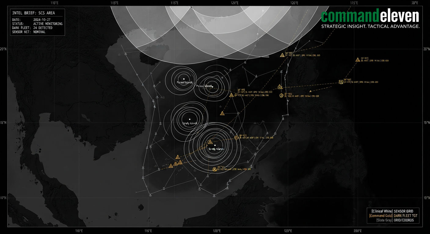
The South China Sea serves as an arena for multi-domain maritime surveillance, resource competition, and naval power projection. Sovereign state actors deploy overlapping sensor networks to enforce territorial claims, track naval movements, and control vital sea lines of communication. This dossier provides a structural assessment of the maritime domain awareness (MDA) infrastructure across the region. It evaluates multi-tiered space, aerial, surface, and subsea surveillance systems, dark fleet tracking methodologies, and coalition intelligence-sharing frameworks intended to counter gray-zone maritime tactics.
Multi-Layer Surveillance Infrastructure Architecture
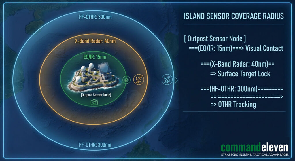
Surveillance coverage in the South China Sea relies on an integrated sensing grid maintained primarily by the People’s Liberation Army Navy (PLAN), the People’s Armed Forces Maritime Militia (PAFMM), and regional littoral states.
Island Base Fortifications and Sensor Nodes
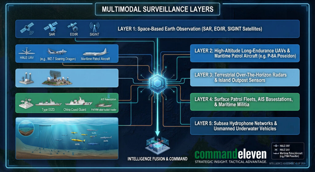
Forward operating bases located on artificial features in the Spratly and Paracel Islands (including Subi Reef, Mischief Reef, and Fiery Cross Reef) function as localized surveillance hubs. These outposts host advanced sensor systems:
- High-Frequency Over-The-Horizon Radars (HF-OTHR): Provide continuous surface tracking beyond the optical horizon, covering ranges up to 300 nautical miles.
- Large-Aperture SIGINT Arrays: Intercept naval high-frequency communications, tactical datalinks, and radar emissions across littoral corridors.
- Electro-Optical / Infrared Tracking Towers: Provide continuous visual and thermal monitoring of adjacent shipping channels and anchorage sites.
Space-Based Constellations
Space-based surveillance provides continuous coverage over the South China Sea. Synthetic Aperture Radar (SAR) satellite constellations penetrate cloud cover and operate independent of solar illumination, yielding high-resolution imagery capable of detecting surface vessel displacements. Combined with radio-frequency (RF) mapping satellites that locate active navigation radars, these space assets enable continuous tracking of non-emitting surface targets.
Dark Fleet Tracking and Signal Obfuscation Tactics
Commercial shipping, illegal fishing, and maritime militia operations frequently employ signal obfuscation techniques to avoid detection. Vessels deliberately deactivate their Automatic Identification System (AIS) transponders or engage in AIS spoofing to disguise their positions and operational intentions.
AI-Enabled Multi-Source Fusion
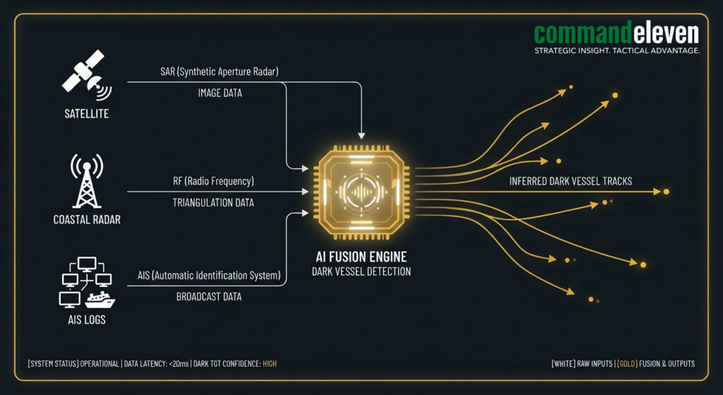
To counter AIS manipulation, maritime intelligence platforms utilize automated multi-source data fusion. Computer vision algorithms process commercial electro-optical satellite imagery to detect unflagged vessels. The system compares physical vessel dimensions against registered AIS databases:
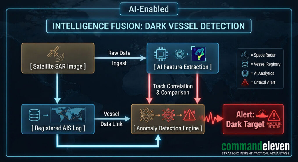
If an optical or SAR satellite detects a vessel at coordinates where no active AIS signal is being broadcast, the target is automatically cataloged as a dark vessel and assigned a tracking vector.
Regional Maritime Domain Awareness Networks
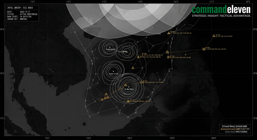
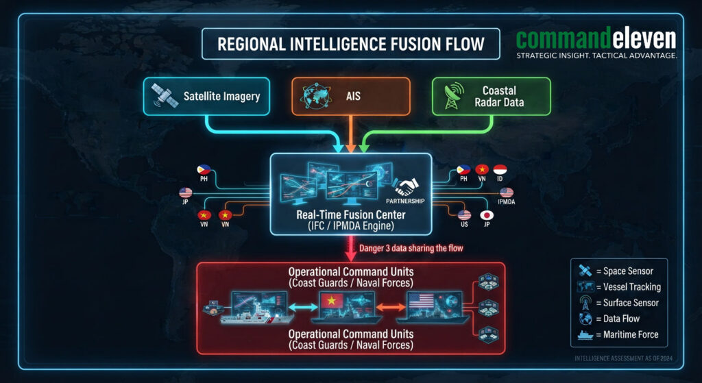
Litigation surrounding maritime boundaries has driven ASEAN member states and international partners to deploy cooperative MDA architectures.
| MDA Initiative / System | Lead Partners | Operational Focus | Primary Sensor Inputs |
| Indo-Pacific MDA (IPMDA) | Quad (US, India, Japan, Australia) | Unclassified commercial monitoring across Southeast Asia | Commercial SAR, satellite AIS, dark vessel analytics |
| Information Fusion Centre (IFC) | Republic of Singapore Navy | Regional commercial shipping risk assessment | Coastal radar networks, naval liaison office reports |
| National Coast Watch Center | Philippines | Littoral surveillance in West Philippine Sea | Coastal radar, UAV feeds, AIS shore stations |
| PLAN Great Underwater Wall | China | Acoustic anti-submarine warfare (ASW) tracking | Seabed hydrophone arrays, UUV acoustic sensors |
The Subsea Domain and Acoustic Monitoring
Surveillance in the South China Sea extends into the subsea environment. Array installations positioned along deep-water trenches monitor submarine transit routes through the Luzon Strait, Malacca Strait, and Mindoro Strait. Seabed acoustic hydrophones connected via fiber-optic cables transmit continuous low-frequency noise signatures to shore processing facilities, tracking subsea movements.
Maritime Chokepoints and Strategic Implications
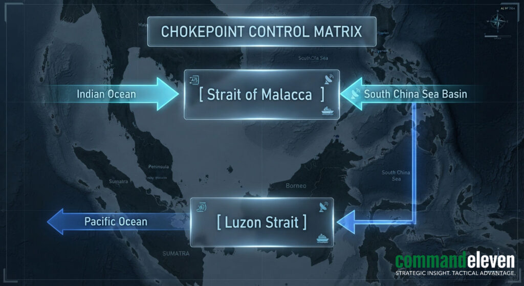
Control over South China Sea transit lanes relies on three critical geographical chokepoints:
Critical SCS Maritime Chokepoints:
- Luzon Strait: The main deep-water entry point between Taiwan and the Philippines connecting the Philippine Sea to the South China Sea, critical for naval surface fleets and submarine deployments.
- Strait of Malacca: The primary commercial maritime corridor linking the Indian Ocean to the Pacific Ocean, handling over twenty-five percent of global sea-borne trade.
- Sunda and Lombok Straits: Deep-water bypass routes through the Indonesian archipelago utilized by heavy displacement merchant vessels and military submarines.
The combination of continuous space-based SAR coverage, forward island sensor platforms, and automated machine learning analytics has eliminated blind spots across the South China Sea. State actors equipped with real-time domain awareness can rapidly deploy naval assets or maritime militia formations to enforce territorial claims, transform gray-zone encounters, and monitor opposing military forces.