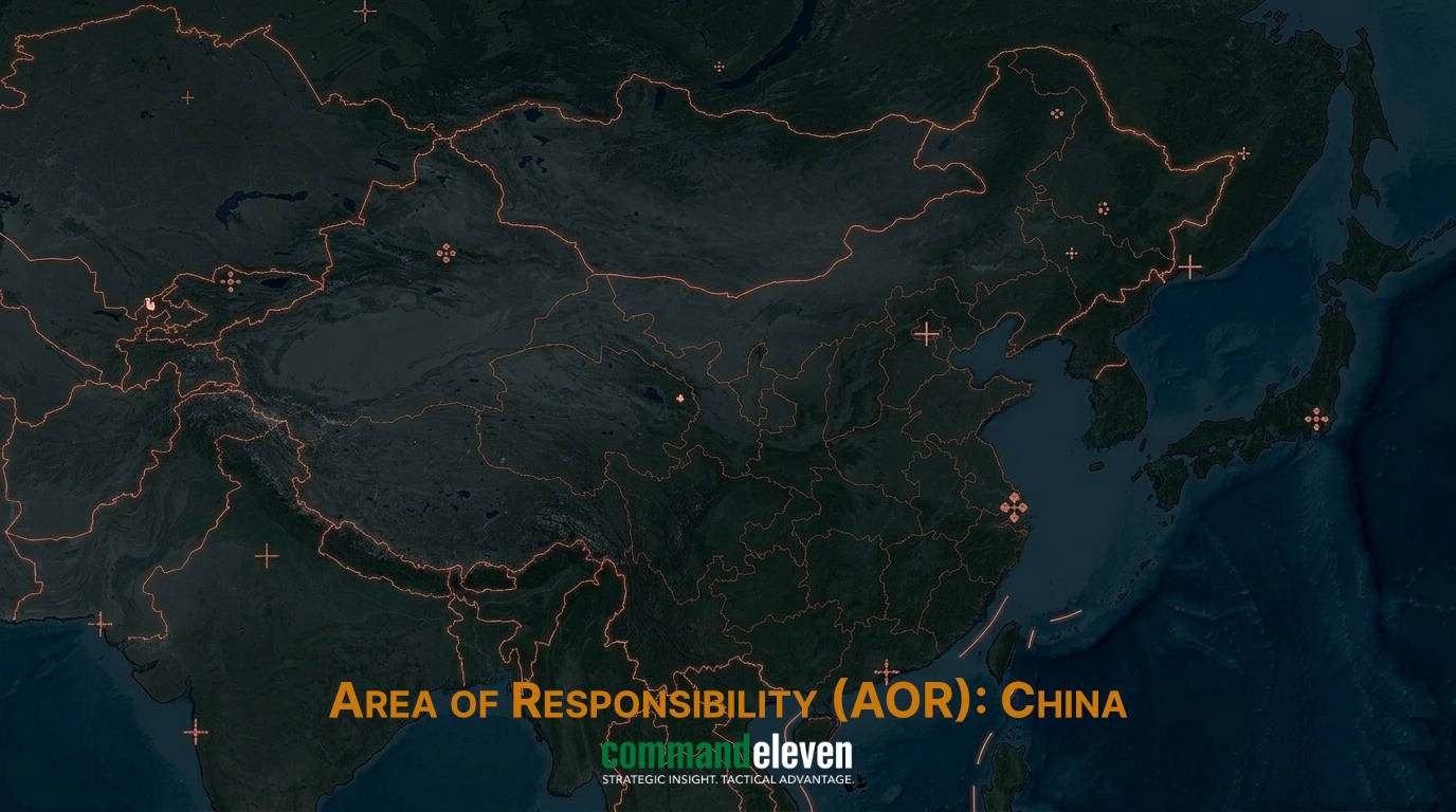
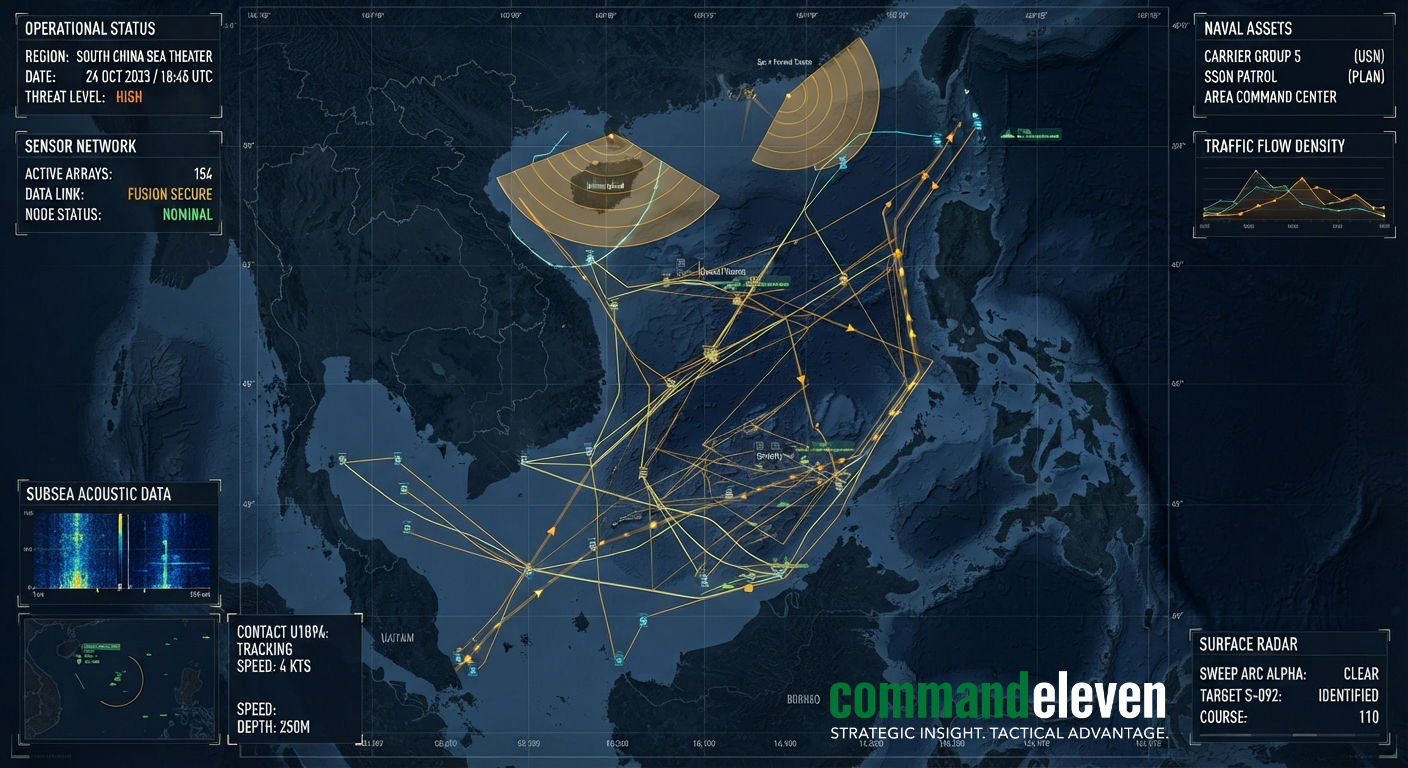
Executive Summary & Maritime Domain Architecture
Throughout 2025 and into late 2026, the People’s Liberation Army (PLA) has expanded its multi-layered Command, Control, Communications, Computers, Intelligence, Surveillance, and Reconnaissance (C4ISR) topology across the South China Sea (SCS). By fully integrating militarized artificial island outposts with space-based persistent infrared/SIGINT arrays, high-frequency over-the-horizon radars, and seabed acoustic tracking grids, Beijing has constructed an operational ISR coverage zone covering over 3 million square kilometers.
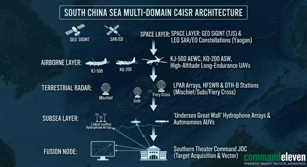
This dossier provides a technical audit of the PLA’s South China Sea sensor infrastructure, detailing radar physics, subsea acoustic monitoring networks, satellite tracking constellations, and the data-fusion mechanics that feed targeting solutions directly into long-range anti-ship missile kill chains.
Artificial Island Outposts as Strategic Sensor Anchors
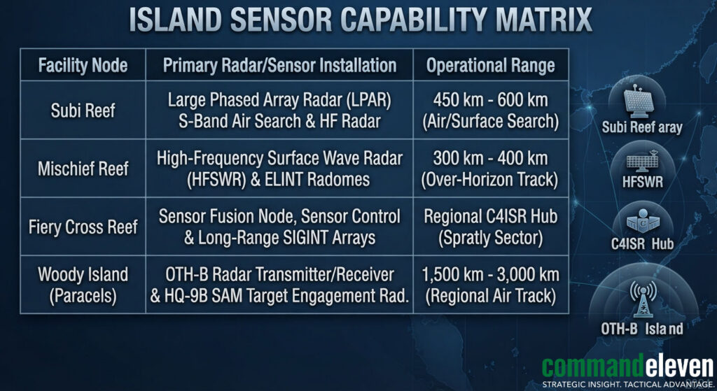
The fortified island bases in the Spratly (Fiery Cross, Subi, Mischief Reefs) and Paracel (Woody Island) archipelagos function as unsinkable C4ISR platform hubs.
Large Phased Array Radars (LPAR) & Electronic Intelligence (ELINT)
- LPAR Architecture: Fixed radar domes housed on Subi, Mischief, and Fiery Cross Reefs utilize active electronically scanned arrays (AESA) operating in the S-band and X-band frequencies. These systems provide multi-target tracking, beam-forming flexibility, and resistance to electronic countermeasures (ECM).
Over-The-Horizon (OTH) Radar Networks
- High-Frequency Surface Wave Radar (HFSWR): Operating in the $3text{ MHz} – 30text{ MHz}$ high-frequency band, HFSWR systems deployed on Mischief and Subi Reefs exploit diffraction around the curved ocean surface to track naval surface vessels far beyond the visual radar horizon out to ranges of $300text{ km} – 400text{ km}$.
- Skywave OTH-Backscatter (OTH-B): Linked to mainland stations in Guangdong and Hainan, OTH-B installations bounce HF signals off the ionosphere down to the sea surface, granting detection of carrier strike groups and airborne assets across distances reaching $2,700text{ km} – 3,700text{ km}$.
The “Undersea Great Wall” Acoustic Monitoring Grid
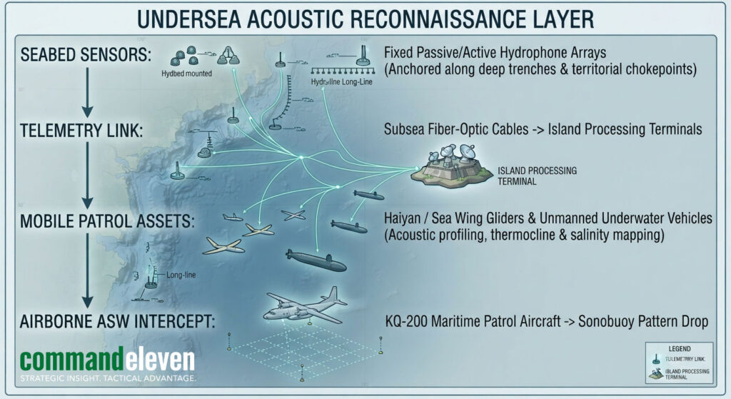
Below the surface, China has deployed a comprehensive subsea hydrophone sensor network,known as the “Blue Ocean Information Network” or “Undersea Great Wall”,designed to neutralize Western submarine stealth advantages within the deep-water basin of the South China Sea.
Seabed Hydrophone Nodes and Fiber-Optic Telemetry
- Fixed Array Deployment: Seabed hydrophone arrays are anchored along critical deep-water channels, including the Bashi Channel, Mindoro Strait, and the continental shelf margins of the Spratly Islands down to depths of $2,000text{ meters} – 4,000text{ meters}$.
- Real-Time Data Transmission: Hydrophones monitor low-frequency acoustic emissions generated by submarine propulsion systems and nuclear reactor cooling pumps. Sensor signals are transmitted via fiber-optic ocean cables directly to island-based signal processing centers for automated acoustic signature matching against known threat databases.
Autonomous Underwater Vehicles (AUVs) and Bathythermographic Profiling
- Acoustic Gliders (Haiyan / Sea Wing): Long-endurance buoyancy-driven gliders continuously traverse the South China Sea water column. These platforms capture real-time oceanographic telemetry,specifically temperature, salinity, and current gradients (bathythermographs).
- Tactical Utility: Mapping thermocline ducting layers allows PLA Anti-Submarine Warfare (ASW) controllers to calculate acoustic shadow zones, optimizing the search patterns of KQ-200 ASW aircraft and surface combatant variable-depth sonar (VDS) systems.
Space-Based ISR and Airborne SIGINT Architecture
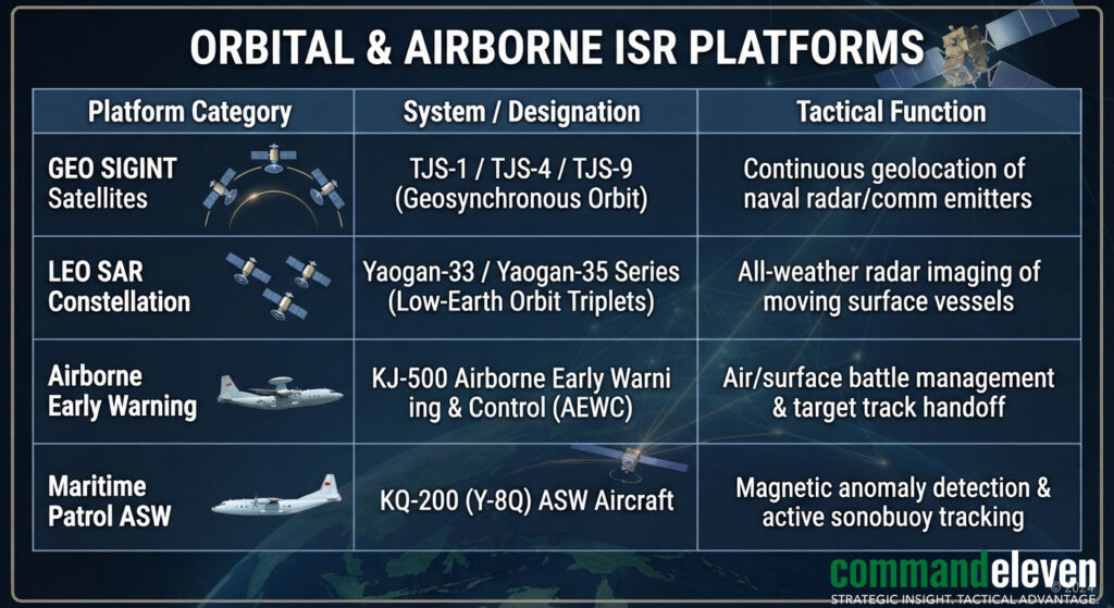
Orbital systems provide the strategic tier of the PLA’s kill-chain, guaranteeing un-interrupted target tracking across the First and Second Island Chains.
Orbital SIGINT & SAR Satellites
- Geosynchronous SIGINT (TJS Satellites): Satellites stationed in geosynchronous orbit continuously monitor radio frequency (RF) emissions across the Indo-Pacific, passively geolocating naval radar emissions, tactical data-links, and satellite communication signals.
- Low-Earth Orbit (LEO) Triplet Formation: The Yaogan satellite series operates in close-formation triplets using Time Difference of Arrival (TDOA) and Frequency Difference of Arrival (FDOA) passive radio-interferometry to pinpoint the exact location, heading, and speed of naval surface vessels through cloud cover and darkness.
Target Acquisition Synthesis and Anti-Ship Kill-Chain Integration
The primary objective of the PLA’s South China Sea sensor architecture is feeding high-fidelity target tracking data into the Southern Theater Command Joint Operations Center (JOC) in Zhanjiang to support long-range anti-ship missile strikes.
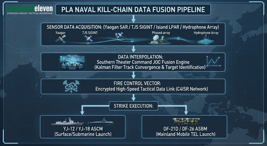
- Detection & Unification: Multi-domain sensors detect a surface combatant group. Sensor data (optical, radar, SIGINT, acoustic) is transmitted via satellite and subsea fiber links to the Southern Theater Command.
- Track Convergence: Automated command algorithms fuse disparate sensor inputs into a single target track, mitigating target location error (TLE).
- Terminal Mid-Course Guidance Update: Fire control solutions are uploaded to launched YJ-12/YJ-18 anti-ship cruise missiles or land-based DF-21D / DF-26 anti-ship ballistic missiles (ASBMs). During mid-course flight, satellite data-links stream updated TLE adjustments directly to the missile seeker prior to terminal terminal radar lock-on.
Strategic Intelligence Indicators & Key Metrics
To measure the operational posture and combat readiness of China’s South China Sea C4ISR grid through late 2026, intelligence collection must monitor:
- LPAR Pulse Emission Densities: Changes in operational frequencies and scan rates emitted by phased array radars at Subi, Mischief, and Fiery Cross Reefs during Western naval exercises.
- LEO SAR Triplet Orbital Insertion Rates: Density and revisit times of newly launched Yaogan SAR satellite constellations covering the South China Sea deep-water basin.
- Acoustic Sensor Telemetry Activity: Subsea cable maintenance vessel activity near deep-water trenches along the Bashi Channel and Spratly periphery.
- Airborne ISR CAP Frequency: Weekly operational flight hours recorded for KJ-500 AEWC and KQ-200 ASW aircraft staging out of forward airfields on Woody Island and Fiery Cross Reef.