3 Key Takeaways
- Flashpoint Concentration: Sabina Shoal has replaced older observation zones as the primary arena for aggressive gray-zone enforcement actions.
- Asymmetric Naval Pressure: The deployment of the 12,000-tonne “Monster” cutter demonstrates Beijing’s willingness to use overwhelming hull sizes to control contested spaces.
- Allied Countermeasures: The integration of real-time Allied data links is crucial for neutralizing the Maritime Militia’s dark fleet tactics, keeping tracking channels open despite electronic spoofing.
Executive Summary
The confrontation profile within the First Island Chain has intensified around Sabina Shoal (also tracked as Escoda Shoal), emerging as the primary flashpoint for maritime domain awareness (MDA) competition in the region. Throughout the first half of 2026, the China Coast Guard (CCG) has altered its deployment strategies, concentrating its presence to enforce administrative blockades within the Philippine Exclusive Economic Zone (EEZ).
CommandEleven Intelligence assesses that Beijing’s current maneuvers are designed to establish permanent control over Sabina Shoal, using it as a forward-deployed tracking outpost to limit Philippine sovereignty. This dossier details the maritime deployments at Sabina Shoal, analyzes recent resource reallocations by the CCG, and outlines the combined countermeasures implemented under the U.S.-Philippine tactical data integration framework.
The Sabina Shoal (Escoda) Standoff Profile
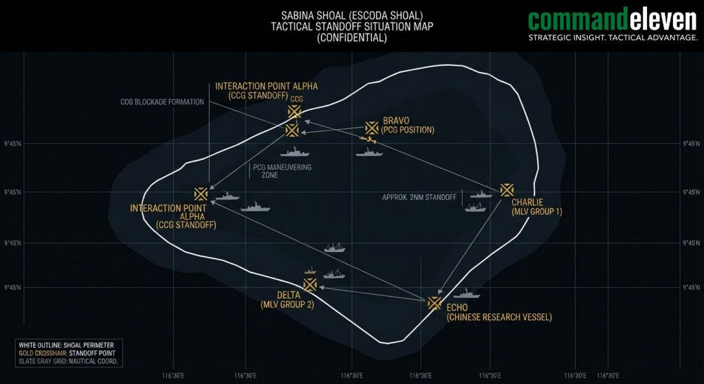
Sabina Shoal is a low-tide elevation situated 75 nautical miles southwest of Palawan Island, placing it inside the Philippines’ 200-nautical-mile EEZ. Because it lacks sovereign territorial waters of its own under UNCLOS rules, the shoal has become an active arena for gray-zone enforcement maneuvers.
The BRP Teresa Magbanua Baseline
To counter suspected Chinese reclamation activities, the Philippine Coast Guard (PCG) deployed the BRP Teresa Magbanua to maintain a continuous presence at Sabina Shoal. Beijing responded by deploying its 12,000-tonne, 165-meter Coast Guard cutter, nicknamed “The Monster” due to its massive displacement. This deployment creates a stark asymmetry, using overwhelming hull size to intimidate local Philippine patrol vessels.
High-Intensity Interdiction Incidents
The operational paradigm at Sabina Shoal shifted from passive observation to direct kinetic friction during recent enforcement cycles:
- Tactical Ramming Operations: CCG vessels executed aggressive maneuvers against the PCG cutters BRP Cape Engaño and BRP Bagacay, tearing significant holes in their hulls above the waterline.
- Logistical Denial: The Bureau of Fisheries and Aquatic Resources (BFAR) vessel BRP Datu Sanday was surrounded by an eight-ship intercept formation,including a PLA Navy corvette and multiple CCG cutters,and disabled via water cannons during a resupply mission.
CCG Resource Reallocation and Patrol Prioritization
Data analyzed by the Asia Maritime Transparency Initiative (AMTI) in early 2026 indicates a calculated shift in Beijing’s maritime enforcement footprint.
| Target Geographic Focus | Historical Baseline Posture | 2026 Active Deployment Index | Primary Mission Mandate |
| Scarborough Shoal | Periodic patrol loops. | Continuous, high-density cutter presence. | Total exclusion of regional fishing fleets. |
| Sabina Shoal | Secondary observation point. | Concentrated multi-fleet swarms. | Interdiction of Philippine state resupply assets. |
Chinese analysts defend this concentration of force as a necessary countermeasure to the growing involvement of external powers. Throughout 2025 and mid-2026, the Philippines expanded its maritime security framework by executing joint air-naval maneuvers with the United States, Australia, Japan, Canada, France, and India. This allied cooperation has prompted the CCG to adjust its deployment patterns to clearly assert Beijing’s territorial claims.
Allied Tactical Data Link Integration
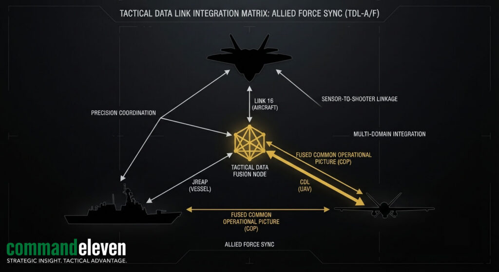
To counter the numerical advantage of Chinese maritime assets, the United States and the Philippines have upgraded their shared intelligence infrastructure. Under the current framework, Allied patrol aircraft (such as US P-8A Poseidons) stream real-time synthetic aperture radar (SAR) data feeds directly into the PCG’s Command Center via secure tactical links.
This tracking network strips away the operational cover of the Maritime Militia’s dark fleets. Even when Chinese vessels disable their AIS transponders or engage in coordinates spoofing, their positions are tracked, identified, and mapped, allowing Philippine vessels to adjust their patrol routes and avoid intercept traps.
Intelligence Assessment & Forecasting (2026–2030)
CommandEleven Intelligence assesses that Sabina Shoal will remain a primary flashpoint for maritime escalation through 2030. Beijing’s focus on Scarborough and Sabina Shoals indicates an intention to establish permanent enforcement barriers within the First Island Chain.
As the Armed Forces of the Philippines continue to resist these blockades, the risk of a severe kinetic incident will increase. The critical factor will be the operational limits of the U.S.-Philippine Mutual Defense Treaty; any attempt by Chinese forces to forcibly tow or disable an anchored PCG vessel like the Teresa Magbanua would risk triggering direct American military support, escalating a localized gray-zone dispute into a broader regional conflict.