
Executive Summary
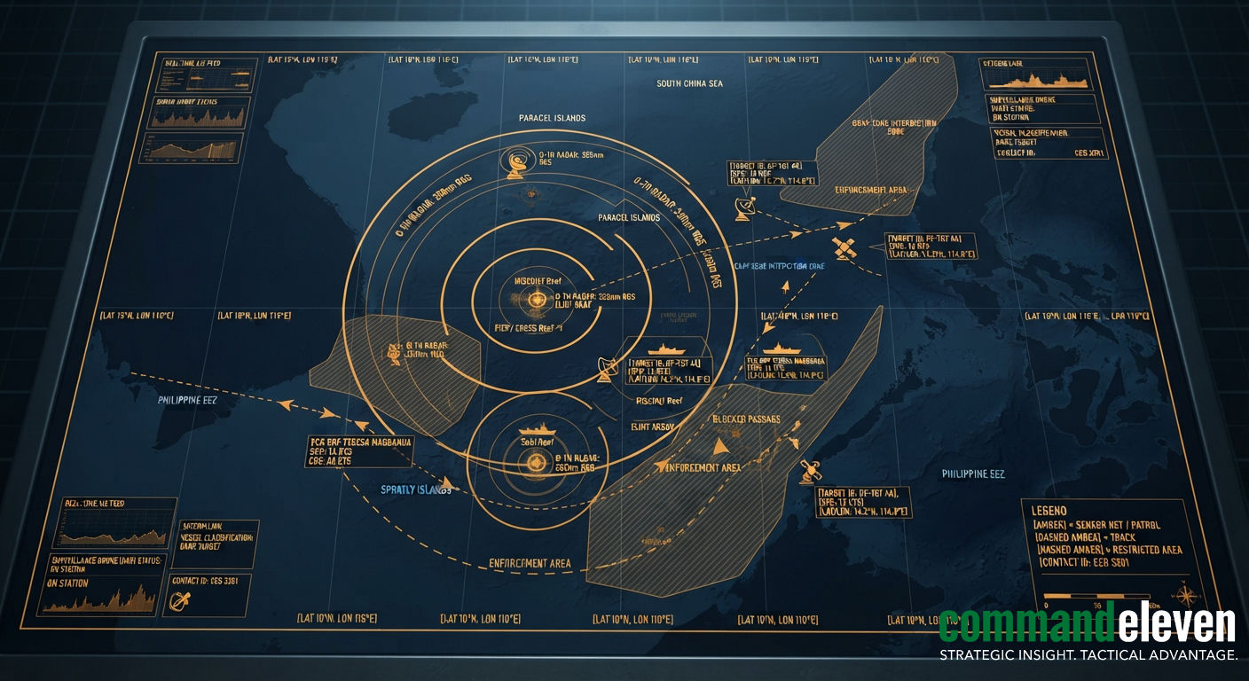
The South China Sea is the most closely watched stretch of water on earth. Over the past decade Beijing has turned its militarized outposts in the Spratly and Paracel Islands into a permanent surveillance grid: over-the-horizon radars, signals intelligence domes, seabed hydrophones, long-endurance drones and radar satellites, all feeding the People’s Liberation Army Navy (PLAN), the China Coast Guard (CCG) and the People’s Armed Forces Maritime Militia (PAFMM). The result is a sea where very little moves unseen inside the Nine-Dash Line.
That grid is not an end in itself. It is the operating system for Beijing’s gray-zone strategy. Real-time tracking lets the coast guard and militia arrive first at Second Thomas Shoal, Sabina Shoal and Scarborough Shoal, block resupply runs, fire water cannon and ram hulls, all while staying below the threshold of armed conflict.
The Philippines, the United States, Japan, Australia and Vietnam have answered with a counter-network of their own: P-8A patrol aircraft, MQ-4C and MQ-9B drones, commercial radar satellites that find “dark” ships, a transparency campaign that puts cameras on every resupply mission, and Vietnam’s own island-building. CommandEleven Intelligence assesses that the contest is no longer about who can see, since both sides now see almost everything. It is about who can process what they see fastest, and who can keep their data links working under jamming and spoofing.
Key Takeaways
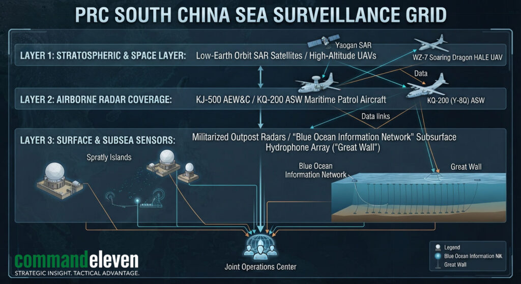
- Near-total domain awareness: The “Big Three” outposts at Fiery Cross, Subi and Mischief Reef, the seabed “Underwater Great Wall” and space-based radar give Beijing continuous tracking of surface and subsurface traffic across the disputed exclusive economic zones (EEZs).
- From patrolling to predicting: Automated cueing lets the CCG pre-position blockades before a Philippine resupply boat reaches a disputed feature, rather than chasing it once it arrives.
- Exposure as a weapon: Manila’s answer is to film everything. Real-time video of ramming and water-cannon attacks has turned Beijing’s “law enforcement” framing into an international liability.
- The data war: Jamming, AIS spoofing and GPS denial on the reefs mean that the decisive targets in a future clash will be the data links between sensors and command centers, not only the ships.
The Outposts: Radar, SIGINT and Airfields
The transformation of Fiery Cross, Subi and Mischief Reef into fortified bases gives the PLA permanent radar, electronic intelligence (ELINT) and communications coverage across the southern half of the sea. In the north, Woody Island anchors the same role in the Paracels.
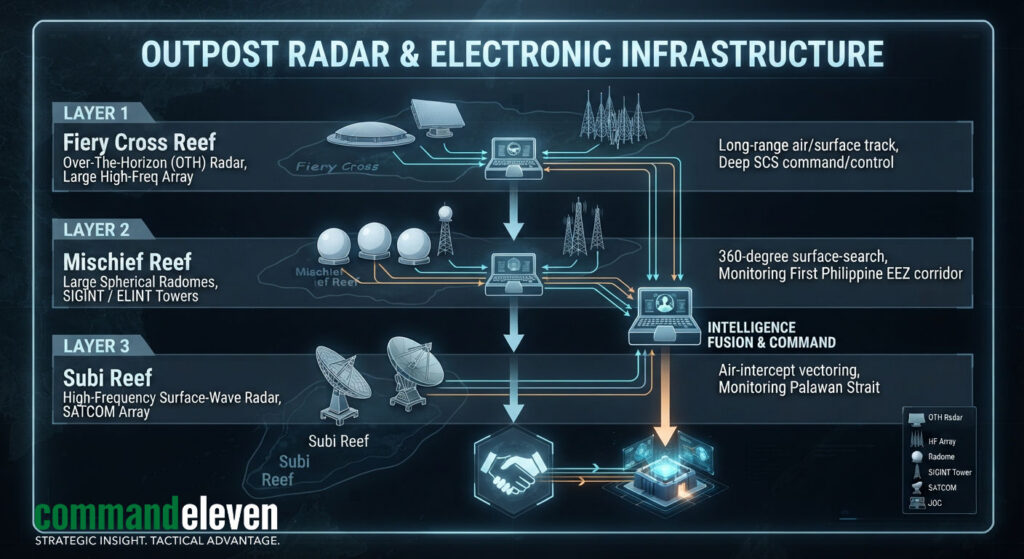
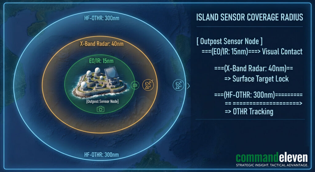
- Over-the-horizon and high-frequency radar: High-frequency surface-wave radar (HFSWR) and over-the-horizon (OTH) installations on the Big Three outposts detect surface ships and low-flying aircraft well beyond the normal radar horizon, at ranges of roughly 300 to 500 kilometers. Their coverage now reaches across the EEZs of the Philippines, Malaysia and Vietnam.
- SIGINT radomes: Dense clusters of radomes house passive collection arrays that catalog foreign military radio traffic, radar emissions and satellite uplinks. Over time this builds an emitter library of Western and ASEAN platforms operating in the region, including traffic through the Palawan and Luzon corridors.
- Electro-optical and infrared towers: Day-and-night camera towers watch nearby shipping channels and anchorages.
- Forward airfields: Hardened hangars support rotations of KJ-500 airborne early warning aircraft and KQ-200 maritime patrol and anti-submarine aircraft, extending low-altitude radar coverage over the Dangerous Ground. Strike fighters (J-11 and J-16) have deployed on a rotational basis.
Drones and Satellites
Above the outposts sits an airborne and orbital layer. WZ-7 high-altitude, long-endurance (HALE) drones fly persistent orbits from forward airfields, providing targeting data over contested features such as Second Thomas Shoal and Scarborough Shoal for land-based anti-ship missile units. The supersonic WZ-8 reconnaissance drone, launched from H-6 bombers, adds a fast collection option.
China’s synthetic aperture radar (SAR) constellations, such as the Yaogan series, see through the cloud and tropical storms that blind optical satellites, refreshing target tracks for surface units every few hours. Radio-frequency mapping satellites locate ships by the emissions of their navigation radars, which lets analysts follow vessels that have switched off their transponders.
Beijing’s reach extends beyond its own sensors. Dozens of states, particularly in Africa and parts of Southeast Asia, have built China’s BeiDou satellite navigation system into their commercial and security maritime networks. That gives Beijing indirect visibility into global maritime traffic and a standard that favors Chinese port automation and logistics software.
Below the Surface: The “Underwater Great Wall”
To counter Western attack submarines and protect its own ballistic missile submarines at Yulin Naval Base on Hainan Island, China has laid an extensive seabed sensor network across the sea’s key troughs and entry points.
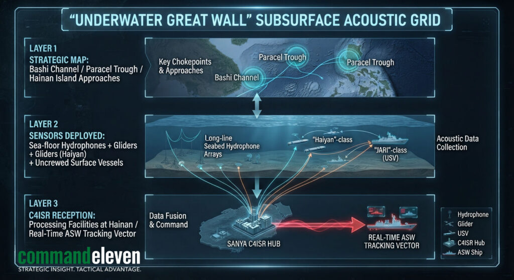
- Seabed hydrophone arrays: Passive hydrophone chains along submarine transit corridors, including the Bashi Channel, the Luzon Strait, the Mindoro Strait and the deep trenches around the Paracels, record acoustic signatures and send them to shore processing centers over fiber-optic cable.
- Ocean gliders and uncrewed surface vessels: Fleets of Haiyan and Sea-Wing underwater gliders, together with BeiDou-linked surface drones and wave-gliders, run multi-week deployments measuring thermocline depth, salinity and currents. That data sharpens China’s anti-submarine sound-propagation models and helps PLA submarines choose quieter routes.
The Maritime Militia and AIS Deception
The maritime militia gives Beijing a scalable tool for controlling disputed waters while staying short of open conflict.
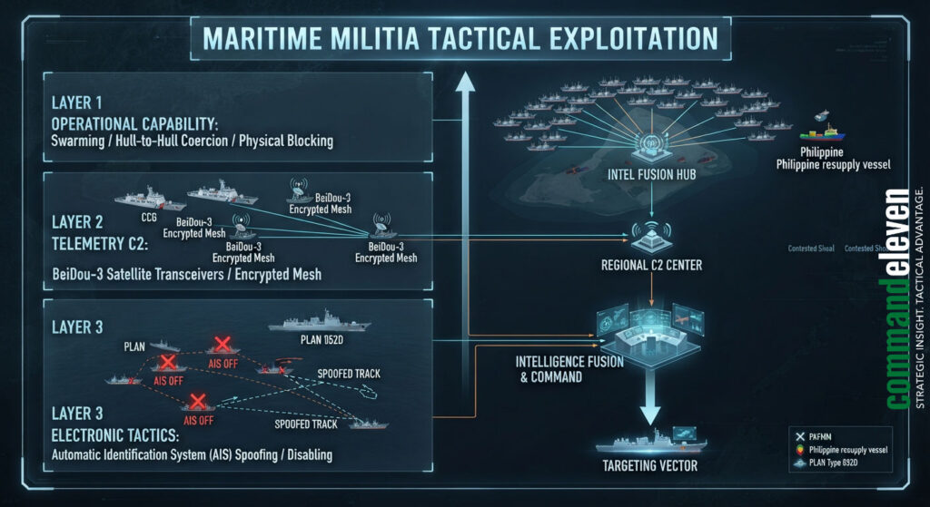
- Spratly Backbone Fleets: Purpose-built, steel-hulled “fishing” vessels with water cannon, reinforced bows for ramming and dedicated communications gear operate out of ports in Guangdong and Hainan.
- BeiDou command links: BeiDou-3 transceivers let CCG and PLAN operations centers direct militia vessels in real time, so swarms can gather quickly against a targeted Philippine resupply mission or an allied survey ship.
- Going dark and spoofing: Militia vessels switch off their Automatic Identification System (AIS) transponders during operations, or clone the identity numbers (MMSI) of ordinary cargo ships. PLAN and militia fleets also broadcast false positions to hide the assembly of a swarm, which corrupts the picture shown on open-source tracking sites.
Gray-Zone Interdiction: How the Grid Is Used
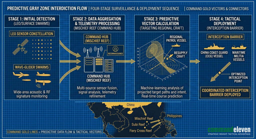
Real-time sensor data turns CCG operations from reactive patrols into predictive interdiction.
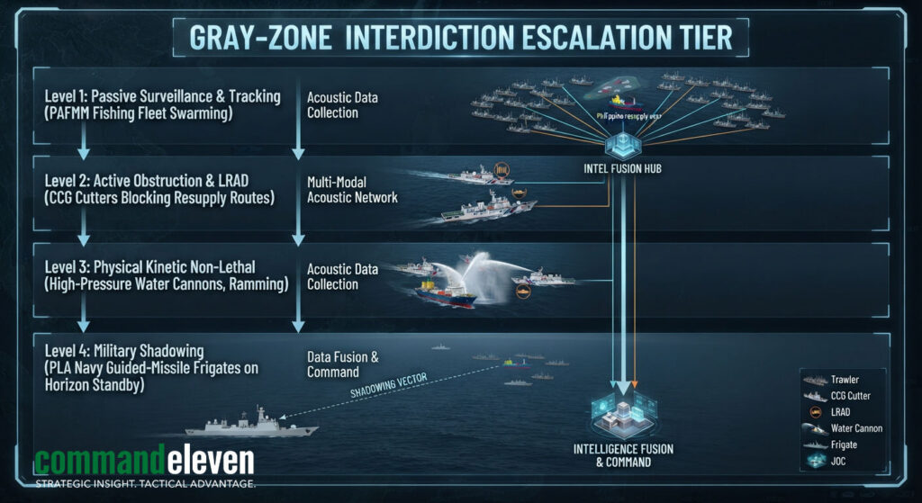
- The militia screen: Militia vessels form the outer envelope, anchoring in large swarms around disputed features such as Thitu Island and Whitsun Reef to physically block fisheries patrols and resupply boats.
- Coast guard enforcement: CCG cutters, including the 12,000-ton Zhaotou-class, are the primary enforcers. Guided by outpost radar, they carry out high-pressure water cannon attacks, use long-range acoustic devices against crews, and bump hulls.
- Pre-positioned blockades: When a Philippine resupply vessel leaves Palawan for Second Thomas Shoal, where the Philippine Navy keeps the grounded BRP Sierra Madre, Chinese radar and satellites calculate its course, speed and arrival time. The CCG is waiting on arrival. Blocking tactics target the small wooden resupply boats while avoiding direct confrontation with escorting US or Philippine naval ships.
- Persistent presence: Automated cueing has let the CCG keep ships at Scarborough Shoal almost continuously, with its patrol days there more than doubling in a year.
- Electronic suppression: Installations on Mischief Reef jam GPS and communications locally, degrading the navigation of patrol boats and fishing craft and forcing them onto backup systems, or onto BeiDou, which reveals their positions in turn.
The Allied Counter-Network
China’s sensor advantage has pushed the region’s other claimants and their partners into building a synchronized counter-network across air, space and sea.
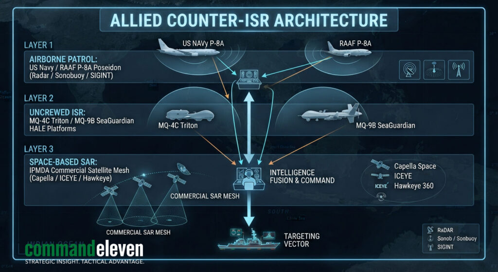
- P-8A Poseidon patrols: Flying from the Philippines, Japan and Australia, US Navy P-8As lay sonobuoy fields to track PLAN submarines and use their APY-10 radar to map surface fleet deployments.
- Long-endurance drones: US Navy MQ-4C Tritons and Japanese and Philippine MQ-9B SeaGuardians provide round-the-clock radar and camera coverage over contested sectors.
- Hand-off overwatch: Allied aircraft and drones operate in coordinated rotations, passing tracks of PLAN flotillas and submarine contacts across national areas of responsibility without escalating to direct confrontation. The Quad expanded this in May 2026 with its Indo-Pacific Maritime Surveillance Cooperation Initiative, announced in New Delhi, which merges commercial satellite data with military tracking.
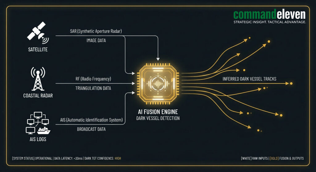
- Finding dark ships: Under the Quad-backed Indo-Pacific Partnership for Maritime Domain Awareness (IPMDA), coastal states receive commercial SAR imagery (from providers such as Capella Space and ICEYE) and radio-frequency tracking (such as HawkEye 360). Computer vision compares the hulls these satellites detect with live AIS feeds; any ship seen where no AIS signal is broadcasting is flagged as a dark vessel and tracked.
Regional surveillance centers
| Initiative | Lead partners | Focus | Main sensor inputs |
|---|---|---|---|
| Indo-Pacific MDA (IPMDA) | Quad (US, India, Japan, Australia) | Unclassified commercial monitoring across Southeast Asia | Commercial SAR, satellite AIS, dark-vessel analytics |
| Information Fusion Centre (IFC) | Republic of Singapore Navy | Regional shipping risk assessment | Coastal radar, naval liaison reports |
| ASEAN Maritime Center | Philippines, with Japanese and Australian satellite feeds | Unclassified data for smaller ASEAN states, including illegal fishing fleets escorted by militia | Satellite telemetry, partner tracking data |
| National Coast Watch Center | Philippines | West Philippine Sea littoral surveillance | Coastal radar, drone feeds, AIS shore stations |
| Underwater Great Wall | China | Anti-submarine acoustic tracking | Seabed hydrophones, underwater drones |
The transparency campaign
Manila’s most effective counter has been exposure. The Philippine Coast Guard has fitted its fleet with high-definition and night-vision cameras and embeds domestic and foreign journalists on resupply missions. Live video of CCG ramming and water-cannon attacks at Sabina Shoal and near Pag-asa (Thitu) Island, paired with recorded AIS tracks, has undercut Beijing’s claim that it is simply enforcing domestic law.
Vietnam builds its own bubble
Vietnam has taken the opposite route to the Philippines and built. It has sharply accelerated reclamation across its Spratly features, creating close to nine square kilometers of new land, including a roughly three-kilometer runway on Barque Canada Reef. That lets Hanoi base maritime patrol aircraft and long-range radar of its own and watch Chinese movements in the southern sector independently.
Chokepoints
Control of South China Sea traffic turns on three geographic chokepoints, each now under continuous watch.
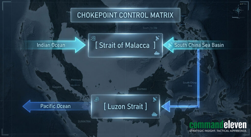
- Luzon Strait: The main deep-water entry between Taiwan and the Philippines, essential for surface fleets and submarine deployments.
- Strait of Malacca: The principal commercial corridor between the Indian and Pacific Oceans, carrying roughly a quarter of global seaborne trade.
- Sunda and Lombok Straits: Deep-water bypass routes through the Indonesian archipelago, used by large merchant ships and by submarines.
Comparing the Two Networks
| Layer | China | Allied / Quad | Main weakness |
|---|---|---|---|
| Fixed and coastal | Island OTH radar, ELINT radomes, seabed hydrophones | Partner coastal radar, mobile tracking assets | China’s island bases are fixed, high-value targets exposed to early strikes |
| Airborne | WZ-7 and WZ-8 drones, KJ-500, Y-9 electronic warfare aircraft | P-8A Poseidon, MQ-4C Triton, MQ-9B SeaGuardian | Aircraft face heavy local jamming |
| Space | Yaogan SAR and optical constellations, BeiDou data | Commercial SAR and RF satellites, Western reconnaissance | Data latency and friction in multinational sharing |
Strategic Outlook and Indicators
The standoff will stay at high intensity through the rest of 2026, and CommandEleven Intelligence assesses that it is heading toward a fully automated, algorithmic tracking environment by 2030. Three judgments follow:
- Total domain lock: If Beijing joins its low-orbit satellite tracking to autonomous surface swarms, no vessel will move undetected inside the First Island Chain, which would sharply reduce the usefulness of non-Chinese naval forces in a crisis.
- Cheap asymmetric answers: Smaller claimants will lean on inexpensive land-based anti-ship missiles, such as the BrahMos batteries the Philippines has fielded, linked to mobile, low-signature radar.
- The data war: Future clashes will be decided by processing speed. The prime targets for sabotage or cyber attack will be the links between satellites, sensors and command centers.
Indicators to watch:
- Permanent fighters on the reefs: A move from rotational to permanent basing of J-11 or J-16 fighters at Fiery Cross and Subi Reef.
- Scarborough Shoal construction: Any dredging or earth-moving near Scarborough Shoal, which would complete a radar and strike triangle over the northern sea.
- Encirclement ratios: The number of CCG and militia ships around Philippine positions at Sabina and Second Thomas Shoal relative to escorting Philippine ships.
- Hydrophone expansion: Chinese research vessels laying deep-sea acoustic moorings in the Bashi Channel and Luzon Strait, or extending arrays toward the Mindoro and Lombok Straits.