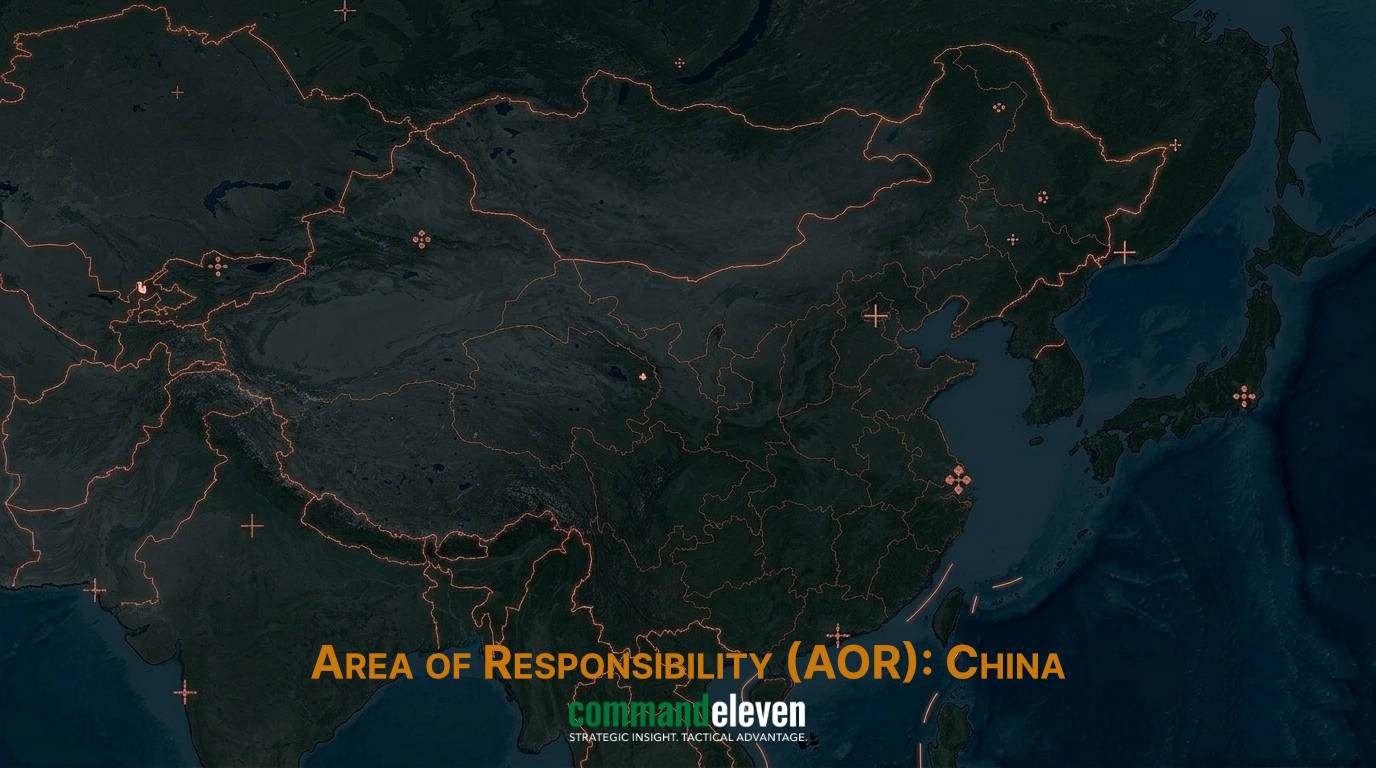
Executive Summary & Domain Context
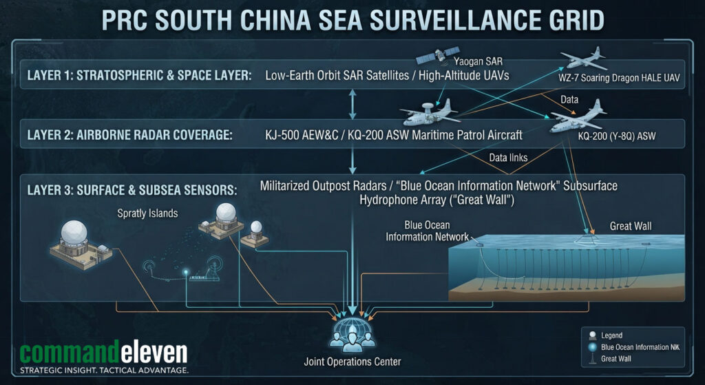
As of August 2026, the South China Sea (SCS) serves as the world’s most densely monitored maritime theater. The People’s Liberation Army (PLA), working in coordination with the China Coast Guard (CCG) and the People’s Armed Forces Maritime Militia (PAFMM), has established a multi-layered, sensor-dense Maritime Domain Awareness (MDA) grid spanning the “Nine-Dash Line.” Centered on militarized artificial outposts in the Spratly and Paracel Islands, this surveillance architecture converts vast oceanic expanses into an integrated sensor array capable of real-time tracking of military and commercial maritime traffic.
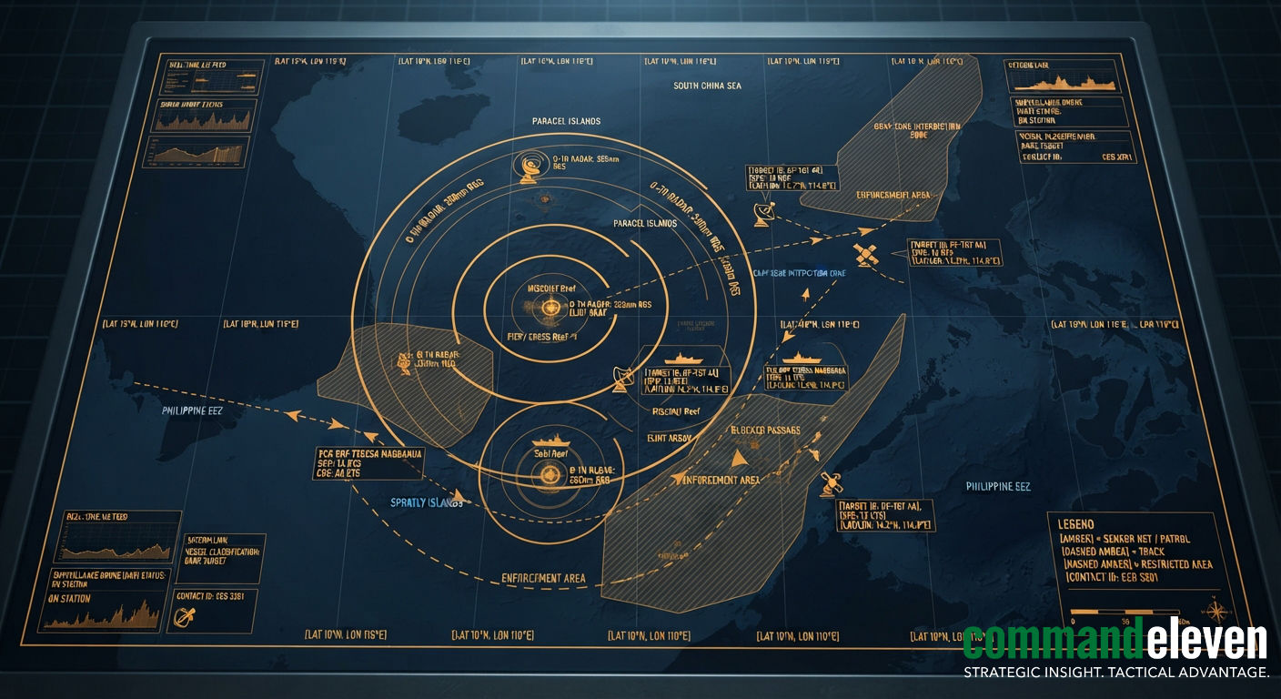
This surveillance infrastructure forms the operational backbone for Beijing’s “gray-zone” strategy. By maintaining real-time tactical tracking over contested features,such as Second Thomas Shoal, Sabina Shoal, and Scarborough Shoal,PRC maritime forces deploy non-kinetic coercion, water cannon interdictions, acoustic dazzling, and physical blockades to deny rival littoral claimants access to their Exclusive Economic Zones (EEZs) without triggering formal armed conflict.
Sensor Integration across Militarized Outposts
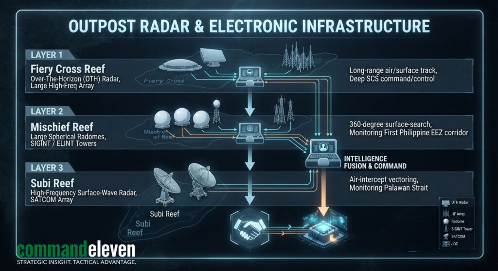
The transformation of Subi Reef, Mischief Reef, and Fiery Cross Reef into fortified military bases provides the PLA with permanent radar, electronic intelligence (ELINT), and communications coverage across the southern sector of the SCS.
Over-The-Horizon (OTH) and High-Frequency Radars
- Beyond-Line-of-Sight Tracking: The deployment of High-Frequency Surface-Wave Radar (HFSWR) and OTH installations on the “Big Three” outposts exploits skywave diffraction to detect surface vessels and low-flying aircraft far beyond traditional horizon limits ($300text{ km} – 500text{ km}$ range).
- Radome & SIGINT Towers: Dense clusters of radomes housing passive electronic intelligence arrays monitor and catalog foreign military radio emissions, radar signatures, and satellite uplink signals, building an emitter library of Western and ASEAN military platforms operating in the region.
Airborne and Space-Based Integration
- Forward-Deployed AEW&C: Hardened aircraft hangars on Fiery Cross, Subi, and Mischief Reefs support routine rotations of KJ-500 Airborne Early Warning and Control (AEW&C) platforms and KQ-200 maritime patrol/anti-submarine aircraft, extending low-altitude radar coverage across the Dangerous Ground sector.
- Synthetic Aperture Radar (SAR) Satellites: Synthetic Aperture Radar satellite constellations (such as the Yaogan series) provide day/night, all-weather imagery over the SCS, generating updated target tracks for surface tactical teams every few hours.
Subsurface Domain Awareness: The “Underwater Great Wall”
To counter Western attack submarine (SSN) operations and protect its sea-based nuclear deterrent based out of Yulin Naval Base on Hainan Island, China has deployed an extensive subsurface sensor architecture across critical maritime troughs.
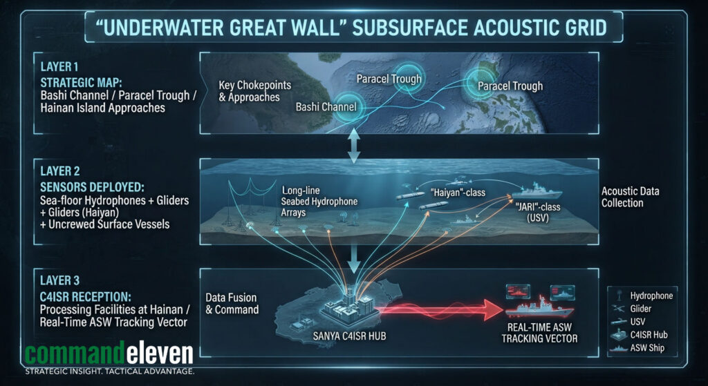
- Seafloor Hydrophone Arrays: Passive hydrophone chains anchor to the ocean floor along key submarine transit corridors, including the Bashi Channel, the Luzon Strait, and the deep-water trenches surrounding the Paracel Islands. These hydrophones record acoustic signatures, feeding data back to onshore processing facilities via subsea fiber-optic cables.
- Autonomous Ocean Gliders: Dozens of Haiyan and Sea-Wing underwater gliders operate continuously across the SCS, gathering physical oceanography data,including thermocline depth, salinity profiles, and current speeds. This data is critical for refining anti-submarine warfare (ASW) acoustic propagation models and optimizing PLA submarine noise-masking routes.
Operational Execution of Gray-Zone Interdiction Tactics
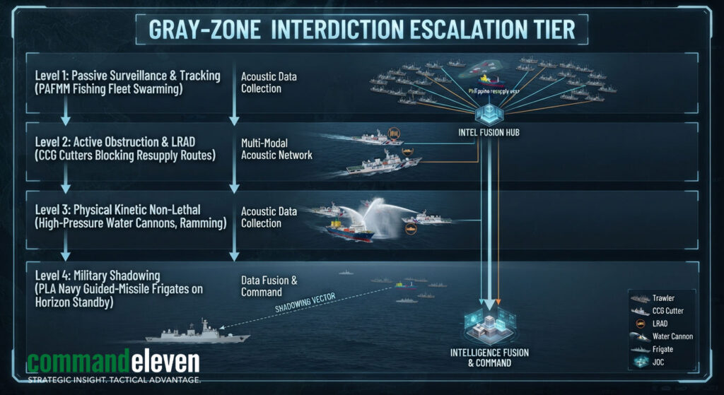
The operational integration of real-time sensor data enables a coordinated, multi-tiered maritime interception strategy designed to exert pressure on rival claimants while managing escalation risk.
Coordinated Swarming and Blockade Tactics
- The PAFMM Layer: The Maritime Militia forms the outer screening envelope. Positioned around disputed features (e.g., Thitu Island, Whitsun Reef), militia vessels anchor in large “swarms,” creating physical barriers to prevent foreign fisheries patrol or resupply vessels from maneuvering.
- CCG Enforcement: China Coast Guard cutters (including 12,000-ton Zhaotou-class vessels) act as the primary operational enforcers. Guided by vectoring data from outpost radars, CCG vessels execute aggressive intercept maneuvers, including high-pressure water cannon attacks, Long Range Acoustic Device (LRAD) acoustic dazzlers, and high-risk hull-to-hull bumping.
Strategic Isolation of Outposts (Second Thomas Shoal Profile)
- Denial of Resupply: At contested features like Second Thomas Shoal (where the Philippine Navy maintains the grounded BRP Sierra Madre), PRC surveillance tracks every inbound resupply rotation from Palawan. CCG and PAFMM ships deploy specialized blocking tactics, targeting wooden re-supply craft while avoiding direct kinetic engagement with escorting US or Philippine naval vessels.
ASEAN and Western Counter-Surveillance Responses
The expansion of PRC surveillance networks has accelerated regional counter-intelligence capabilities, maritime capacity-building, and joint patrol initiatives.
- Philippine “Transparency Initiative”: Manila’s strategy focuses on exposing PRC gray-zone operations by embedding domestic and international journalists on resupply missions. This initiative pairs real-time video broadcasting with AIS track recording to counter PRC state narratives.
- Combined Patrols and P-8A Operations: The US, Australia, Japan, and the Philippines execute joint maritime patrols within Manila’s EEZ. US Navy P-8A Poseidon maritime patrol aircraft conduct low-altitude surveillance flights, deploying sonobuoys and optical systems to monitor PRC subsurface and outpost activities.
- Maritime Domain Awareness Alliances: Under the Quad-led Indo-Pacific Partnership for Maritime Domain Awareness (IPMDA), littoral states receive commercial satellite tracking data, synthetic aperture radar imagery, and unclassified radio-frequency data to track “dark targets” operating with deactivated Automatic Identification System (AIS) transponders.
Strategic Forecasting & Baseline Indicators (H2 2026)
The density of SCS surveillance and gray-zone interdictions will escalate through the remainder of 2026. Key monitoring indicators for intelligence tracking include:
- Permanent Outpost Fighter Deployments: Tracking the operational transition from rotational to permanent basing of J-11D or J-16 strike fighters at Fiery Cross and Subi Reef airfields.
- Scarborough Shoal Dredging/Land Reclamation: Earth-moving equipment movements or initial dredging activity near Scarborough Shoal, which would complete a radar/strike triangle over the northern SCS.
- Bashi Channel Hydrophone Array Expansion: Elevated deployments of oceanographic research vessels dropping deep-sea acoustic moorings within the Bashi Channel and Luzon Strait.