
Technical Takeaways
- Systemic Exploitation of Non-Combatant Immunity: The operational posture of the maritime militia relies on the intentional manipulation of international maritime law. By masking state-directed paramilitary maneuvers under the guise of commercial fishing activity, Beijing exploits the legal protections granted to civilian vessels, forcing defending regional coast guards into complex legal dilemmas that delay decisive interception.
- Bathymetric Data Acquisition for Subsurface Dominance: China’s expanding naval footprint in the Indian Ocean Region is driven by its dual-use hydrographic research fleet. The continuous mapping of deep-sea topography and thermal layers provides the critical environmental data required for long-range, silent subsurface navigation, allowing PLAN submarines to bypass regional sonar detection nets.
- Tactical Deception via AIS Manipulation: The deployment of maritime militia forces and research vessels features advanced electronic masking. By routinely alternating between total transponder deactivation and identity spoofing to mimic standard cargo traffic, these fleets inject significant data clutter into international maritime domain awareness networks, forcing regional command centers to waste critical surveillance resources verifying false targets.
Executive Summary
This dossier delivers a theater-level operational assessment of the People’s Republic of China (PRC) synchronization of physical naval presence, paramilitary swarming, and cognitive operations across critical maritime axes. While international attention remains focused on high-visibility flashpoints within the First Island Chain, the People’s Liberation Army Navy (PLAN) and the People’s Armed Forces Maritime Militia (PAFMM) are executing a long-range campaign of geographic and cognitive encirclement spanning the South China Sea (SCS) and the Indian Ocean Region (IOR).
Operationally, this strategy utilizes a highly coordinated multi-layered architecture: dual-use deepwater port infrastructure (“String of Pearls”), deep-sea hydrographic survey deployments, and massive paramilitary blockades. By manipulating automated identification systems (AIS), fabricating legal and historic baseline records, and staging calculated non-kinetic confrontations, Beijing is systematically altering the maritime security status quo.
The strategic objective is twofold: to normalize the PRC’s creeping administrative occupation of contested global commons and to degrade the regional sea lines of communication (SLOCs) of adversarial middle powers and Western naval groups without crossing the threshold into conventional kinetic escalation.
The South China Sea Force-Multiplication Layer
The tactical integration of the PAFMM alongside the China Coast Guard (CCG) and the PLAN has transitioned into a highly structured, permanent maritime occupation engine. Satellite imagery and maritime tracking data confirm that rather than functioning as localized fishing fleets, the maritime militia maintains a record-high daily presence across the Spratly and Paracel archipelagos, shifting from defensive presence to offensive blockade rehearsals.
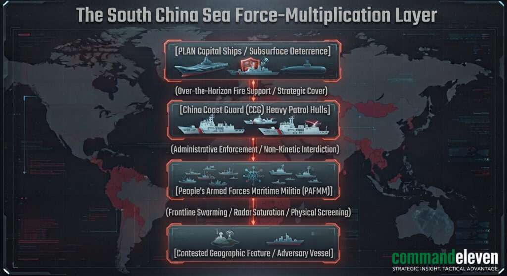
Institutional Structure of the Cordon
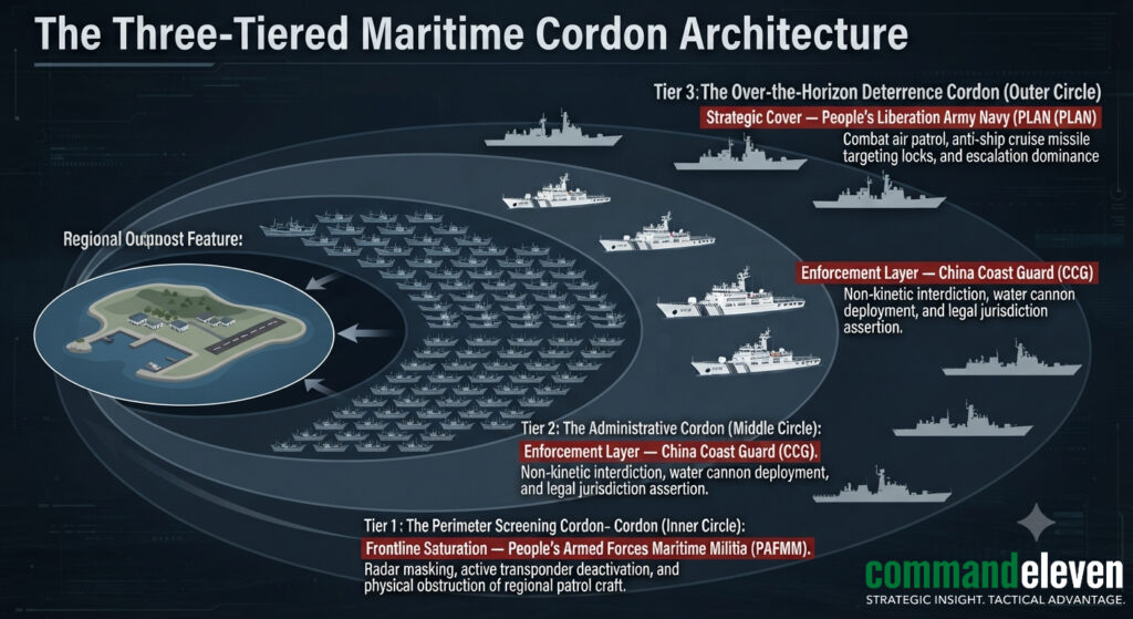
The paramilitary fleet is organized into two distinct, functional layers that execute a coordinated “anaconda squeeze” around contested reefs like Whitsun, Mischief, and Scarborough Shoals:
- The Professional Core: Purpose-built, steel-hulled vessels ranging from 45 to 65 meters in length, operated by full-time, state-salaried militia personnel. These units undergo regular military and political training. They specialize in active gray-zone tactics: executing physical maneuvers to block adversary coast guard hulls, conducting long-range reconnaissance, and intentionally disabling AIS transponders to create tactical ambiguity.
- The Spratly Backbone Fishing Fleet: Numerically superior civilian fishing vessels heavily subsidized by provincial military districts and local governments (primarily out of Zhejiang, Guangdong, and Hainan provinces). While ostensibly pursuing commercial livelihoods, these fleets are massed at anchor inside secured hubs like Mischief Reef. They serve as a persistent, low-signature maritime barrier, ready to be mobilized as an auxiliary force to saturate adversary radar networks and deny access to contested waters.
Blockade Rehearsal Formations
The scale of this mobilization has expanded from localized harassment to large-scale, strategic blockades. Satellite data tracking exercises in the East China Sea and Taiwan Strait reveal formations where over 2,000 maritime militia vessels align in continuous, geometric blockades stretching across 470 kilometers.
These massive walls of ships serve a clear tactical purpose: they test the capacity of regional navies to maintain maritime domain awareness, while demonstrating a non-kinetic capability to completely seal off shipping lanes, isolate island outposts, or obscure the movement of PLAN amphibious strike groups.
The Indian Ocean Power Projection Matrix
To secure its critical energy supply lines and project power into the Western hemisphere, Beijing is rapidly duplicating its South China Sea gray-zone framework within the Indian Ocean Region (IOR). This campaign targets the strategic maritime approaches controlled by India and Western partners, shifting the geopolitical balance of the region.
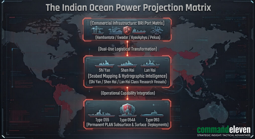
The Dual-Use Logistical Continuum
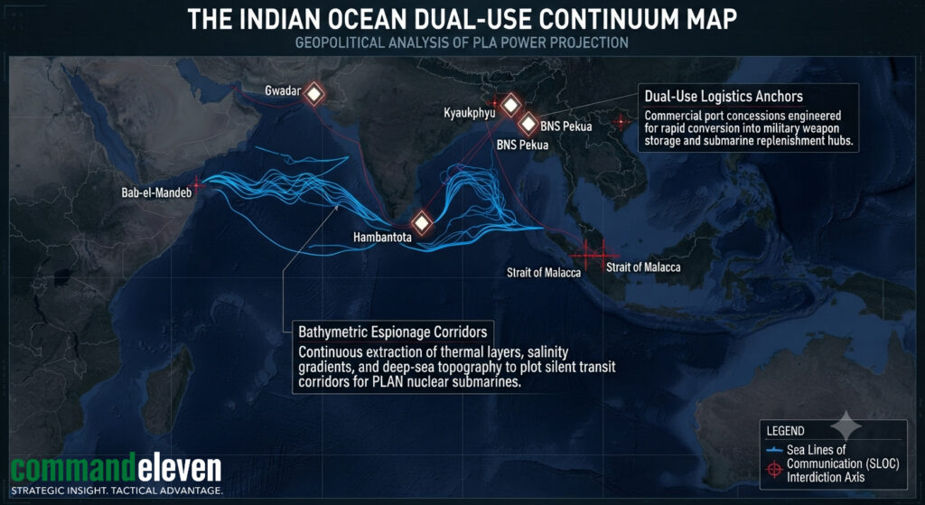
The IOR expansion relies heavily on the “String of Pearls”,a network of commercial deepwater ports developed under the Belt and Road Initiative (BRI). These ports,including Hambantota (Sri Lanka), Gwadar (Pakistan), Kyaukphyu (Myanmar), and BNS Pekua (Bangladesh),are structurally engineered for rapid transition into dual-use military support facilities.
By securing 99-year leases and extraterritorial administrative concessions, China bypasses the need for traditional, formal military alliances. These nodes provide the PLAN with permanent forward logistics platforms, weapon storage depots, and maintenance facilities capable of berthing advanced surface combatants and nuclear attack submarines (SSNs), effectively outflanking India’s traditional maritime defensive perimeters.
Subsurface Mapping and Bathymetric Espionage
The physical deployment of PLAN surface task groups is preceded by a aggressive, continuous hydrographic survey campaign. Specialized Chinese dual-use research vessels,such as the Shi Yan 6, Shen Hai Yi Hao, and Lan Hai 201,operate continuously throughout the Bay of Bengal, the Arabian Sea, and the strategic approaches to the Chagos Archipelago.
These vessels systematically map deep-sea topography, thermal layers, and salinity gradients. This data collection serves a direct military purpose: creating high-fidelity bathymetric models required for long-range, silent subsurface navigation.
By mapping deep-water trenches and underwater choke points, China provides its growing fleet of Type 094 and Type 096 nuclear submarines with secure transit pathways, allowing them to evade detection by regional anti-submarine warfare (ASW) networks while monitoring Western and Indian naval deployments.
The Cognitive Domain Layer: Narrative Exploitation and Information Masking
The physical placement of ships and port infrastructure is tightly integrated with a sophisticated cognitive warfare campaign. Beijing deliberately exploits international legal loopholes and open-source information frameworks to neutralize regional countermeasures.
The Asymmetric Exploitation of Legal Protections
Under the Law of Armed Conflict (LOAC) and the United Nations Convention on the Law of the Sea (UNCLOS), coastal fishing vessels and civilian research ships are granted broad immunities from military interception and attack. The PAFMM intentionally operates within this legal gray zone:
- The Disinformation Inversion: When regional coast guards attempt to enforce maritime boundaries against swarming militia boats, state media networks immediately launch pre-planned, global public relations campaigns. The actions of regional patrol vessels are systematically framed as “unprovoked state aggression against peaceful, civilian fishermen.”
- The Victimhood Frame: By saturating global social media and international organizations with edited video clips and fabricated tracking telemetry, Beijing constructs a narrative that shifts the burden of escalation onto the defending state. This creates significant political and legal friction for democratic leadership structures, introducing hesitation and delaying the decision to deploy naval assets until the physical fait accompli is complete.
Electronic Deception and AIS Manipulation
The maritime militia and Chinese research vessels use electronic spoofing as a primary weapon to distort situational awareness:
- Ghost Fleets: PAFMM vessels routinely operate with deactivated AIS transponders while executing tactical blockades, disappearing from civilian monitoring networks while remaining visible on military-grade radar.
- Identity Spoofing: Vessels switch digital identification beacons to mimic standard commercial cargo ships or regional fishing boats, injecting massive noise into the maritime domain awareness databases of adversarial states. This systematic manipulation of the digital operational picture degrades the target’s ability to accurately evaluate threat levels, forcing regional security centers to expend critical reconnaissance resources verifying hundreds of false targets.
Strategic Vulnerabilities and Countermeasures
The expansion of China’s maritime gray-zone model across the SCS and IOR represents a highly scalable challenge to international maritime governance. By weaponizing civilian-labeled fleets and dual-use commercial hubs, Beijing forces regional competitors into a reactive posture.
Strategic Counter-Measures
To break this momentum, defensive maritime coalitions must exploit the fundamental technical and operational vulnerabilities of this multi-axis campaign:
- Structural Demilitarization and Legal Attribution: The legal protection of the PAFMM depends entirely on the maintaining of their civilian status. Regional maritime coalitions must execute a proactive strategy of persistent, open-source attribution. By utilizing high-resolution satellite imagery, interception audio, and financial records to conclusively link specific fishing fleets and research vessels to the PLA chain of command, international legal bodies can classify the PAFMM as an auxiliary naval force. Stripping their non-combatant status removes their legal immunity, allowing regional coast guards to apply assertive, hard-kill interdiction measures without violating international law.
- Targeted Infrastructure Interdiction: The “String of Pearls” network is geographically dispersed and highly vulnerable to isolation during a crisis. These commercial nodes lack the deep defensive hardening of sovereign military bases. Western and regional navies should develop specialized, localized maritime interdiction capabilities targeting the specific access channels, fuel depots, and data lines feeding Chinese dual-use ports. Isolating these logistical hubs cuts off the forward operational capability of PLAN surface assets, turning their long-range presence into an unsustainable logistical burden.
- Acoustic and Bathymetric Denial: China’s subsurface power projection into the Indian Ocean is completely dependent on the accuracy of the seabed data collected by its research vessels. Rather than attempting to physically block these ships in international waters, defensive forces should deploy active electronic and acoustic countermeasures. By seeding critical underwater choke points with acoustic spoofing devices and variable-frequency sonar arrays, Western and regional navies can distort the bathymetric collection sensors of Chinese research ships. Feeding corrupted, inaccurate thermal and topographical data into their systems neutralizes the strategic value of their mapping campaigns, rendering their subsurface transit routes unsafe for operational deployment.