Executive Summary
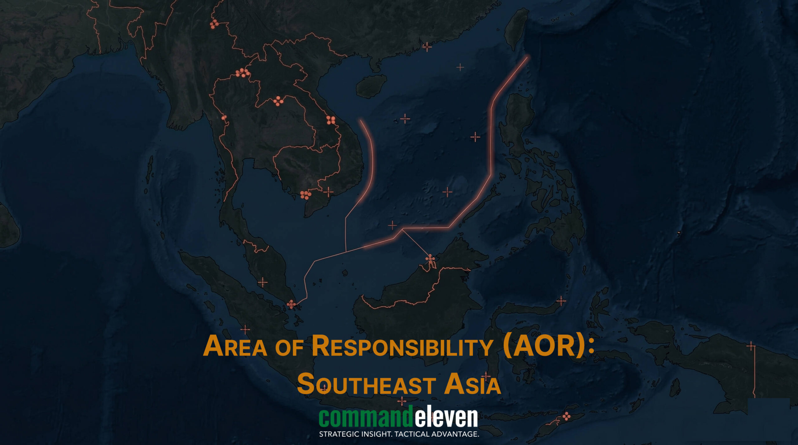
The South China Sea (SCS) has evolved into a fully automated, continuously monitored maritime battlespace as of May 2026. Beijing has successfully operationalized an all-domain Maritime Domain Awareness (MDA) network across the First Island Chain, integrating seafloor acoustic arrays, island-based high-frequency over-the-horizon radars, and autonomous wave-glider fleets. This pervasive sensor web has shifted China Coast Guard (CCG) operations from reactive patrolling to predictive gray zone interdiction, targeted blockades, and electronic communication suppression. CommandEleven Intelligence assesses that regional counter-measures,such as the Philippine transparency campaign and Vietnam’s accelerated island fortifications,are vital asymmetric equalizers, but the strategic balance depends entirely on the data-processing speeds of rival command architectures.
3 Key Takeaways
- Total Domain Lock: China’s integrated “Underwater Great Wall” and high-frequency radar arrays have eliminated traditional tactical surprise, allowing for the continuous tracking of surface and sub-surface assets across disputed exclusive economic zones.
- Predictive Interdiction Versus Visibility: Automated cueing from satellite and unmanned surface fleets allows the CCG to pre-position numerical blockades against regional resupply missions, which littoral states counter by deploying electro-optical sensors to stream real-time evidence of aggression.
- Electronic and Geopolitical Friction: Aggressive localized GPS jamming on militarized reefs is increasingly paired with maritime militia presence to enforce de facto administrative sovereignty below the threshold of kinetic war.
Tactical Summary
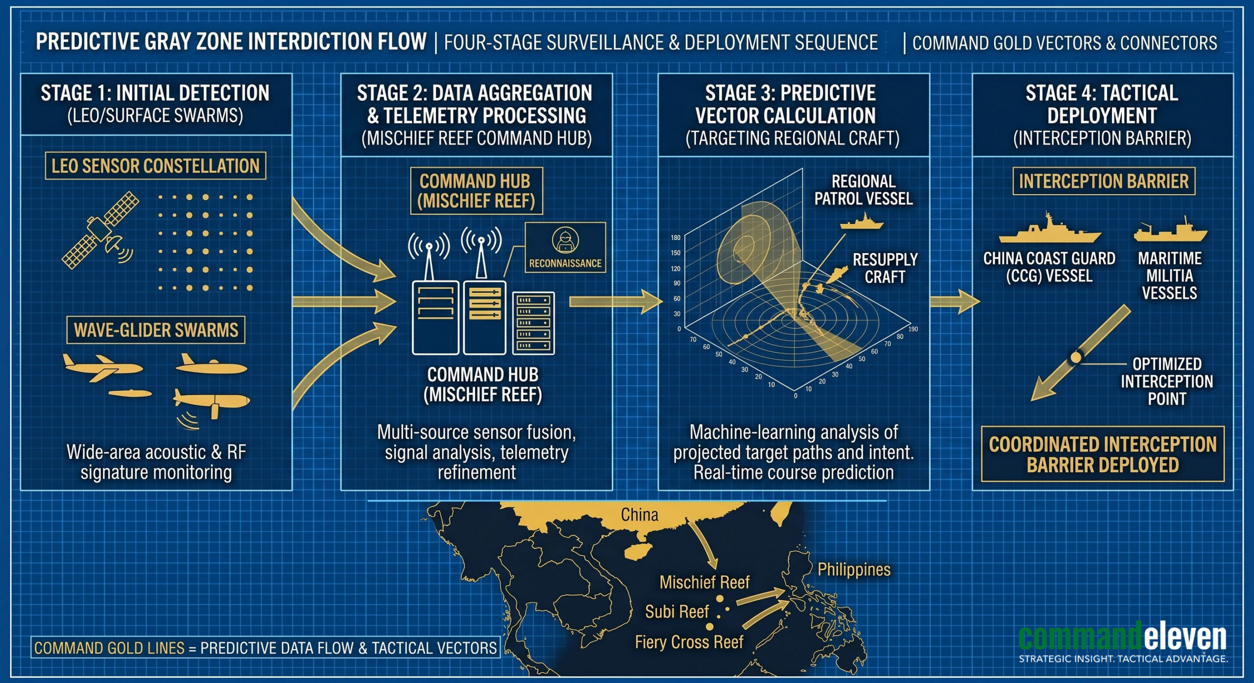
As of May 2026, the South China Sea (SCS) has transformed from a theater of intermittent maritime standoffs into an environment of continuous, automated observation. The operationalization of the Philippine-US Mutual Defense Treaty (MDT) and the deployment of the trilateral ICE Pact frameworks have encountered a massive expansion of China’s maritime sensing capabilities. CommandEleven Intelligence assesses that Beijing has successfully built a continuous, real-time Maritime Domain Awareness (MDA) network across the First Island Chain. This network integrates satellite constellations, unmanned surface vessels (USVs), and fortified island sensors, enabling the China Coast Guard (CCG) and the People’s Liberation Army Navy (PLAN) to execute predictive, high-frequency “gray zone” interdictions against regional claimants, with a specific focus on neutralizing Philippine resupply lines and tracking US naval assets.
The Sensor Web Architecture

The Chinese surveillance network in the SCS relies on a multi-layered, redundant infrastructure designed to eliminate blind spots within the maritime environment.
The Undersea “Blue National Defense” Array
Beijing has completed the deployment of the “Underwater Great Wall,” a comprehensive network of seafloor acoustic sensors, hydrophones, and fiber-optic cables anchored around the Paracel and Spratly Islands. This array provides continuous tracking of submarine acoustic signatures passing through the critical chokepoints of the Luzon Strait and the Bashi Channel, neutralizing the traditional stealth advantage of Western underwater assets.
Terrestrial High-Frequency Radars
The militarized outposts at Subi, Mischief, and Fiery Cross Reefs function as the primary command nodes for regional surveillance. In early 2026, China finalized installation of advanced Over-the-Horizon Backscatter (OTH-B) and Active Electronically Scanned Array (AESA) radar systems on these features. These sensors project a continuous radar coverage zone extending across the entire exclusive economic zones (EEZs) of the Philippines, Malaysia, and Vietnam, stripping those nations of tactical surprise within their own coastal waters.
Autonomous Surface Telemetry (USV Fleets)
Supplementing fixed island bases, Beijing has deployed swarms of Beidou-enabled autonomous surface vessels and wave-gliders. Showcased at the Digital China Summit in April 2026, these unmanned platforms operate on multi-week deployment cycles, collecting oceanographic, thermal, and acoustic data. This persistent presence provides the predictive modeling necessary to guide CCG interceptors toward regional fishing and patrol vessels long before they reach disputed features like Scarborough or Sabina Shoals.
Littoral Counter-Measures and the Transparency Campaign
The response of littoral states,led by the Philippines and supported by regional allies,has shifted from passive diplomatic protest to active, sensor-driven asymmetric exposure.
Real-Time Imagery Dissemination
The Philippine Coast Guard (PCG), operating under a revised maritime strategy, has systematically integrated high-definition, night-vision electro-optical sensors across its patrol fleet. By capturing real-time video evidence of CCG ramming maneuvers and water-cannon deployments,such as the incidents at Sabina Shoal and Pag-asa Island,Manila has successfully weaponized international public opinion, degrading Beijing’s efforts to frame its actions as legal domestic law enforcement.
Vietnam’s Landfill and Fortification Acceleration
Confronted by China’s sensor dominance, Vietnam has significantly accelerated its reclamation activities across 21 features in the Spratly Islands, creating nearly nine square kilometers of new land by early 2026. The doubling of the land area on Barque Canada Reef and the construction of a 3.2-kilometer runway allow Hanoi to deploy indigenously developed maritime patrol aircraft and long-range radar arrays, establishing an independent defensive sensor bubble capable of monitoring Chinese movements in the southern sector of the SCS.
Multilateral Intelligence Integration
The establishment of the ASEAN Maritime Center in the Philippines in May 2026 marks a structural shift toward institutionalized information sharing. Supported by satellite telemetry feeds from Japan and Australia, the center functions as a non-aligned clearinghouse for unclassified maritime data, providing smaller ASEAN littoral states with the tracking tools required to monitor illegal, unreported, and unregulated (IUU) fishing fleets escorted by Chinese maritime militia vessels.
The Tactical Impact on Gray Zone Interdiction

The optimization of Chinese sensor networks has shifted CCG operations from reactive patrols to predictive interdiction.
- The Presence Multiplier: According to verified tracking metrics, the CCG maintained an unprecedented presence at Scarborough Shoal throughout the past year, with patrol days more than doubling to 1,099 ship-days due to automated cueing from satellite and USV networks.
- Targeted Blockades: When a Philippine resupply vessel departs Puerto Princesa, Chinese satellite and coastal radars calculate its vector, speed, and ETA immediately. This allows the CCG to pre-position numerical blockades at Second Thomas Shoal, executing precise intercept maneuvers that minimize fuel expenditure while maximizing tactical containment.
- Electronic Warfare Suppression: Alongside visual monitoring, Chinese installations on Mischief Reef have deployed localized GPS and communications jamming arrays. These systems degrade the navigation suites of regional patrol vessels and civilian fishing craft, forcing them to operate blindly in highly hazardous waters.
Intelligence Assessment & Forecasting (2026–2030)
CommandEleven Intelligence assesses that the South China Sea surveillance paradigm will transition into a fully automated, algorithmic tracking environment by 2030.
- The Total Domain Lock: If left unchecked, China’s integration of LEO satellite tracking with autonomous surface swarms will create an environment where no maritime vessel can move undetected within the First Island Chain, reducing the operational viability of non-Chinese naval assets during a crisis.
- Littoral Asymmetric Response: Smaller claimant states will increasingly rely on inexpensive, land-based anti-ship missile batteries (such as the BrahMos system deployed by the Philippines) linked to mobile, low-signature radar nodes to offset China’s naval superiority.
- The Data War: Future maritime skirmishes will be won or lost based on data processing speeds. The primary target for sabotage or cyber-kinetic interference will not be the physical ships, but the data links connecting orbital sensors to terrestrial command centers.