Executive Summary & Strategic Context
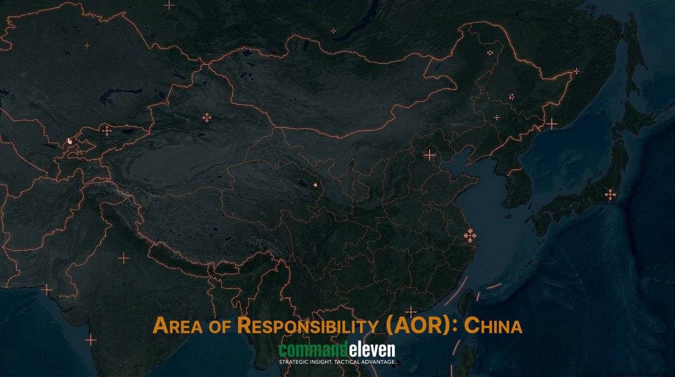
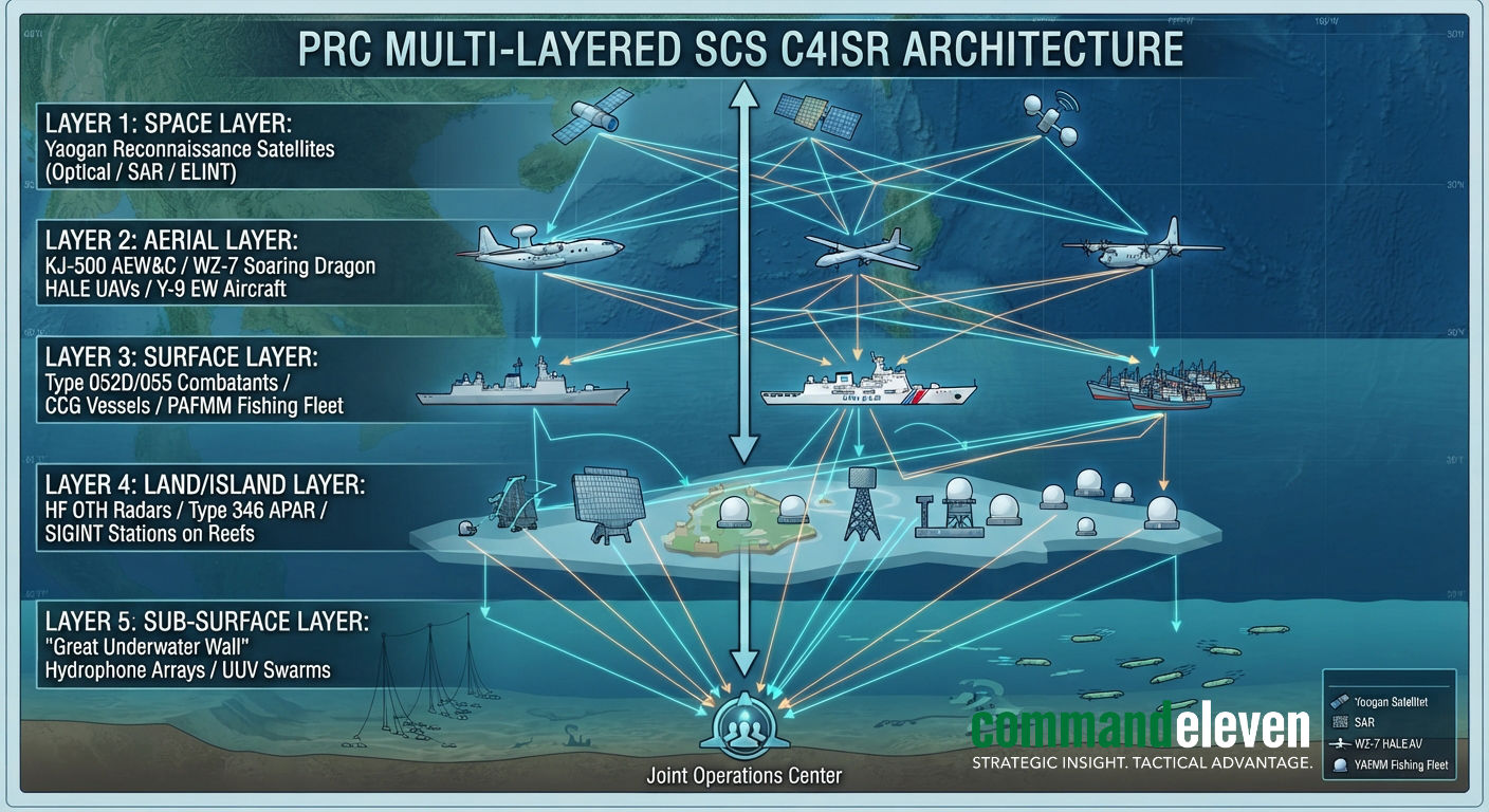
As of July 2026, the South China Sea (SCS) represents the world’s most densely sensor-saturated maritime domain. The People’s Republic of China (PRC) has completed the integration of its “Fortress Fleet” strategy, transforming artificial features in the Spratly (Fiery Cross, Subi, Mischief Reefs) and Paracel Islands (Woody Island) into a fully networked, multi-domain C4ISR (Command, Control, Communications, Computers, Intelligence, Surveillance, and Reconnaissance) complex.
This infrastructure is engineered to enforce a persistent, real-time Anti-Access/Area-Denial (A2/AD) envelope covering the entire Nine-Dash Line area. In response, littoral ASEAN states,led by the Philippines and Vietnam,alongside the United States and allied partners, have deployed counter-surveillance, maritime domain awareness (MDA) grids, and strategic transparency operations designed to blind, spoof, and expose PRC gray-zone and military incursions.
PRC Multi-Layered Sensor Grid Architecture
Fixed Terrestrial & Island-Based Radar Arrays
- High-Frequency Over-The-Horizon (HF OTH) Radars: Installed on Subi and Mischief Reefs, these systems utilize skywave and surface-wave propagation to detect surface vessels and low-RCS (Radar Cross-Section) aircraft beyond the horizon, extending the PRC’s early-warning perimeter over 1,000 kilometers from the mainland coastline.
- Active Electronically Scanned Array (AESA) Enclosures: The primary militarized outposts feature large radomes housing high-power, multi-band (S-band, X-band, C-band) search and fire-control radars. These systems provide precise tracking data directly integrated with HQ-9B surface-to-air missile (SAM) systems and YJ-12/YJ-18 anti-ship cruise missile (ASCM) batteries deployed permanently on the features.
- SIGINT & ELINT Intercept Stations: High-frequency direction-finding (HF/DF) antennas and passive signal monitoring arrays cover the island outposts, intercepting commercial and military VHF/UHF communications, satellite uplinks, and radar emissions across the entire SCS maritime transit corridor.
Aerial ISR and Space-Based Constellations
- Airborne Early Warning & Control (AEW&C) Orbits: Continuous, overlapping air patrols conducted by KJ-500 and KJ-200 aircraft operating out of hardened shelters on Fiery Cross and Woody Island project low-altitude radar coverage over deep-water approaches, neutralizing low-flying cruise missiles or sea-skimming targets.
- High-Altitude Long-Endurance (HALE) Unmanned Systems: Deployments of WZ-7 Soaring Dragon and EA-03 HALE drones provide persistent, real-time optical, infrared, and synthetic aperture radar (SAR) imaging of foreign naval strike groups. These assets feed targeting data to Southern Theater Command fire-control centers via satellite link.
- Space-Based Reconnaissance Layer: The Yaogan satellite constellation (comprising optical imaging, SAR, and Triplet-ELINT formation-flying satellites) provides persistent target tracking capability, maintaining orbital revisits over the SCS every 15–30 minutes to track capital ship movements.
Sub-Surface Sensing: The “Great Underwater Wall”
- Fixed Passive Sonar Networks: Sea-floor hydrophone arrays anchored around critical chokepoints (Luzon Strait, Malacca Strait approaches, and surrounding the Spratly feature boundaries) monitor low-frequency acoustic signatures emitted by foreign nuclear and diesel-electric submarines.
- Autonomous Unmanned Underwater Vehicles (UUVs): Deployment of long-endurance ocean gliders (Haiyan series) gathering real-time bathythermographic data (salinity, temperature, current profile). This data is critical for calibrating anti-submarine warfare (ASW) acoustic propagation models and optimizing PLAN submarine routing.
Gray-Zone Surveillance, AIS Manipulation & Electronic Warfare
PRC maritime domain dominance relies heavily on non-kinetic, asymmetric operations that obfuscate military presence while projecting constant pressure against littoral states:
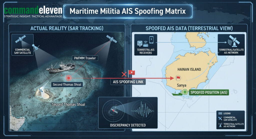
- People’s Armed Forces Maritime Militia (PAFMM) AIS Manipulations: Hundreds of heavily reinforced, steel-hulled militia vessels operating under the guise of commercial fishing fleets utilize digital obfuscation tactics:
- AIS Transponder Spoofing: Transmitting false Maritime Mobile Service Identity (MMSI) numbers, manipulating GPS coordinates to project positions hundreds of miles away, or turning off transponders entirely (“going dark”) during coordinated swarming operations around disputed features (e.g., Scarborough Shoal, Whitsun Reef).
- Vessel Monitoring System (VMS) Masking: Utilizing proprietary PRC state-controlled VMS networks that allow national command elements to track militia positions via satellite while remaining invisible to international AIS tracking networks.
- High-Powered RF & Optical Disruption:
- Laser Interdiction: Ground-based and shipboard military-grade dazzlers systematically target the optics of foreign maritime patrol aircraft (such as US Navy P-8A Poseidons and Philippine Coast Guard Cessna 208s) to blind flight crews and disrupt surveillance photography.
- Localized GPS/GNSS Jamming: Deployed mobile EW suites on Spratly outposts periodically flood the L1/L2 GNSS bands, causing civilian maritime navigation displays in surrounding waters to report inaccurate positioning or lose satellite lock completely.
ASEAN & Allied Counter-Surveillance Architecture
To counter PRC domain dominance, ASEAN littoral states, in coordination with external partners, have fielded a distributed counter-surveillance framework:
- The Philippines’ Transparency Initiative & MDA Modernization:
- Publicizing Gray-Zone Actions: The Philippine Coast Guard (PCG) embeds specialized photojournalists and intelligence camera crews on resupply missions (e.g., to BRP Sierra Madre at Second Thomas Shoal), utilizing high-resolution long-range optics and satellite uplinks to stream real-time footage of CCG/PAFMM water cannon usage, ramming tactics, and acoustic device deployments directly to global media.
- Coastal Radar Integration: Deployment of modern Japanese- and Israeli-supplied coastal surveillance radars along the western coastline of Palawan and Luzon, providing continuous tracking of surface contacts inside the Philippine Exclusive Economic Zone (EEZ).
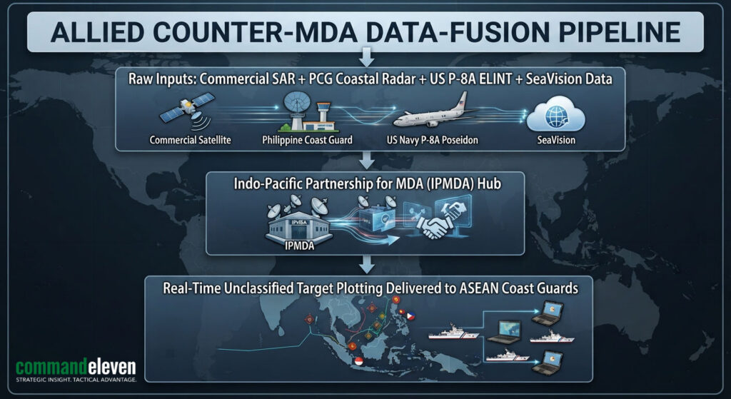
- The Indo-Pacific Partnership for Maritime Domain Awareness (IPMDA):
- Commercial SAR Satellite Integration: IPMDA feeds commercial Synthetic Aperture Radar (SAR) imagery,which penetrates cloud cover and operates at night,directly to ASEAN maritime command centers. By cross-referencing SAR satellite detection data with AIS broadcasts, dark targets (militia vessels with transponders off) are instantly identified and plotted on real-time operational displays.
- Vietnam’s Hardened Island Reconnaissance Network:
- Vietnam has quietly completed major dredging and fortification efforts across its occupied features in the Spratly Islands (e.g., Barque Canada Reef). These sites feature modern radomes, SIGINT towers, and reinforced artillery emplacements capable of tracking both PRC island bases and PLAN transit corridors in the southern SCS sector.
Strategic Outlook & Interdiction Vulnerabilities
While the PRC’s SCS C4ISR network appears formidable, it possesses structural vulnerabilities that define the strategic threshold:
- High-Value Node Fragility: The island outposts in the Spratlys are statically positioned, geographically isolated, and exceptionally vulnerable to saturation kinetic strikes or high-power electro-magnetic pulse (EMP)/counter-electronics weapons. In a hot conflict, their radars and communication towers would be neutralized in the opening hours, rendering the forward sensor grid dark.
- Data-Saturation & Fusion Bottlenecks: Processing the massive volume of raw sensor data generated by thousands of commercial vessels, militia boats, aircraft, and satellite passes strains Southern Theater Command’s target processing capabilities. Misidentification and automated signal clutter remain constant points of friction.
- The Transparency Metric: The Philippine strategy of weaponizing real-time visual intelligence has stripped the PRC of its primary gray-zone advantage: plausible deniability. As additional ASEAN nations adopt low-cost SAR tracking and public domain exposure protocols, the strategic efficacy of PRC maritime militia operations will continue to decay.